
Bradfield, Norfolk
| Bradfield | |
|---|---|
 Saint Giles Parish Church, Bradfield | |
 Bradfield Location within Norfolk | |
| OS grid reference | TG2733 |
| • London | 135 miles (217 km) |
| Civil parish | |
| District | |
| Shire county | |
| Region | |
| Country | England |
| Sovereign state | United Kingdom |
| Post town | NORTH WALSHAM |
| Postcode district | NR28 |
| Dialling code | 01263 |
| Police | Norfolk |
| Fire | Norfolk |
| Ambulance | East of England |
Bradfield is a village and former civil parish, now in the parish of Swafield, in the North Norfolk district, in the county of Norfolk, England.[1] The village is 7.6 miles (12.2 km) south south east of Cromer, 18.1 miles (29.1 km) north north east of Norwich and 135 miles (217 km) north east of London. The village lies 3.1 miles (5.0 km) north north west of the town of North Walsham. In 1931 the parish had a population of 136.[2]
History[edit]
Bradfield's name derives from the Anglo-Saxons and refers to a broad area of open country.[3]
Bradfield is not mentioned in the Domesday Book.[4]
On 1 April 1935 the parish was abolished and merged with Swafield.[5]
Transport[edit]
The nearest railway station is at Gunton for the Bittern Line which runs between Sheringham, Cromer and Norwich. The nearest airport is Norwich International Airport.
Sport[edit]
Bradfield Cricket Club has roots dating back to the late 1800s when a group of farm workers were allowed to play cricket on one of Bradfield Hall Farm fields. Over the years the ground has developed and now boasts one of the best playing surfaces and outfields in the whole of the Norfolk Cricket Alliance.
Saint Giles' Church[edit]
Bradfield's parish church is dedicated to Saint Giles and is very large church for what is now a small community. The church, however was once bigger still.[6] There is evidence of this both inside and out, because the north and south arcades were filled in when the aisles were demolished. The pillars and arches can still be seen, set in the walls, the early 14th century capitals revealing the age of the church.
The porch is dated 1786, along with the churchwardens' names, which is probably shortly after the aisles were demolished.[7] At the east end of the church there is a decorated window and pentagonal buttresses with stone pinnacles added in 1864 when some restoration work was carried out on the church. Above the chancel arch there is a wall painting of Christ in Judgment. He sits on a rainbow showing his wounds. The wall painting dates from the 15th century.[8]
Church gallery[edit]
-
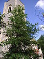 The church tower
 -
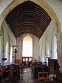 The chancel viewed from the altar
 -
 The altar and east window
 -
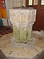 The font
.JPG)
.JPG)
.JPG)
.JPG)
War memorial[edit]
Bradfield's war memorial takes the form of a brass plaque located inside St. Giles' Church. It holds the following names for the First World War:
- Lance-Corporal John S. Futter (d.1917), 8th Battalion, Rifle Brigade (The Prince Consort's Own)
- Private Robert F. S. Futter (1894–1915), 10th Battalion, Essex Regiment
- Private Herbert J. Hewitt (d.1915), 1st Battalion, Royal Norfolk Regiment
- Private Percy Hammond (1891–1916), 2nd Battalion, Royal Norfolk Regiment
- Private Ernest Towler (d.1915), 2nd Battalion, Northumberland Fusiliers[9]
References[edit]
- ^ Ordnance Survey, Explorer Sheet 252, Norfolk Coast East, ISBN 978-0-319-46726-8
- ^ "Population statistics Bradfield CP/AP through time". A Vision of Britain through Time. Retrieved 17 September 2022.
- ^ University of Nottingham. (2022). Retrieved November 6, 2022. http://kepn.nottingham.ac.uk/map/place/Norfolk/Bradfield
- ^ Domesday Book. (1086). Retrieved November 6, 2022. https://opendomesday.org/map/
- ^ University of Portsmouth and JISC. (2017). Retrieved November 6, 2022. https://www.visionofbritain.org.uk/unit/10160777
- ^ Pesvner, N and Wilson, B. (1999). The Buildings of England: Norwich and North-east Norfolk. London: Penguin.
- ^ Mee, A. (1972). The King;s England, Norfolk. London: Hooder & Stoughton.
- ^ Ibid
- ^ Edwards, M. (2004). Retrieved November 6, 2022. http://www.roll-of-honour.com/Norfolk/Bradfield.html
External links[edit]
![]() Media related to Bradfield, Norfolk at Wikimedia Commons
Media related to Bradfield, Norfolk at Wikimedia Commons