
Vistulan Boulevards, Warsaw
| Vistulan Boulevards in Warsaw | |
|---|---|
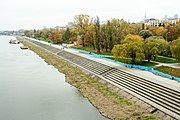
 Boulevards near Śląsko-Dąbrowski Bridge | |
 | |
| Type | Boulevards |
| Location | Warsaw, Poland |
| Coordinates | 52°08′27″N 21°01′21″E / 52.1408°N 21.0224°E |
| Created | 2015 |
| Status | Open year round |
Vistula boulevards (Polish: Bulwary wiślane) form a continuous riverside promenade on the left (west) bank of the River Vistula in Warsaw, Poland. The section between Poniatowski Bridge and Śląsko-Dąbrowski Bridge is named after Bohdan Grzymała-Siedlecki,[1] and between the bridges of Śląsko-Dąbrowski and Gdański after Jan Karski.[2]
The reconstruction of the boulevards began in 2013.[3] The opening of the boulevards was planned for the July,[4] and then autumn of 2014.[5] Later dates of the opening of the boulevards at Podzamcze was estimated to be April 2015, and the segment to Copernicus Science Centre in mid-2015.[6]
The first segment of the Vistulan Boulevards was opened on August 2, 2015.[7]
Gallery[edit]
-
 Vistulan Boulevards in Powiśle, in the foreground is the Świętokrzyski Bridge.
 -
 The Boulverads near Copernicus Science Centre
 -


References[edit]
- ^ "Bulwar Bohdana Grzymały-Siedleckiego". Urząd Miasta Warszawa. Retrieved 5 March 2016.
- ^ "Obiekty". Ulice. Retrieved 5 March 2016.
- ^ "Koparki ryją Wisłę". TVN Warszawa. Retrieved 5 March 2016.
- ^ "Opóźnienia w rewitalizacji bulwarów wiślanych". Polityka Warszawska. Retrieved 5 March 2016.
- ^ "Nowe bulwary dopiero jesienią. Budowa opóźniona". TVN Warszawa. Retrieved 5 March 2016.
- ^ "Nowe bulwary dopiero jesienią. Budowao późniona". Gazeta Wyborcza. Retrieved 5 March 2016.
- ^ "Bulwar Jana Karskiego gotowy". Urząd Miasta Warszawa. Retrieved 5 March 2016.
This Poland location article is a stub. You can help Wikipedia by expanding it. |