
Angiriai
Angiriai | |
|---|---|
Village | |
 | |
 Angiriai Location in Lithuania  Angiriai Angiriai (Lithuania) | |
| Coordinates: 55°16′59″N 23°45′00″E / 55.28306°N 23.75000°E | |
| Country | |
| County | |
| Municipality | Kėdainiai district municipality |
| Eldership | Josvainiai Eldership |
| Population (2011) | |
| • Total | 153 |
| Time zone | UTC+2 (EET) |
| • Summer (DST) | UTC+3 (EEST) |
Angiriai or Angeriai (meaning 'a place on woods', formerly Russian: Онгиры, Polish: Ongiry) is a village in Kėdainiai district municipality, in Kaunas County, in central Lithuania. According to the 2011 census, the village had a population of 153 people.[1] It is located 8 kilometres (5 mi) from Josvainiai, on the left bank of the Šušvė river, by the dam of the Angiriai Reservoir, near the Josvainiai Forest.
History[edit]
An ancient stone axe has been found in Angiriai.[2] At the beginning of the 20th century there was Angiriai manor and okolica.[3]
Demography[edit]
|
| |||||||||||||||||||||||||||||||||
| Source: 1902, 1923, 1959 & 1970, 1979, 1989, 2001, 2011 | ||||||||||||||||||||||||||||||||||
Images[edit]
-
 A blockhouse and memorial stone for the villages of Angiriai surroundings
 -
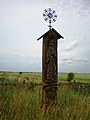 A roofed pole with the image of St. Mary near Angiriai


References[edit]
- ^ "2011 census". Statistikos Departamentas (Lithuania). Retrieved August 21, 2017.
- ^ "Angiriai". Tarybų Lietuvos enciklopedija (in Lithuanian). Vol. 1. Vilnius: Vyriausioji enciklopedijų redakcija. 1985. pp. 65–66.
- ^ "Ongiry". Geographical Dictionary of the Kingdom of Poland (in Polish). 15 pt. 2. Warszawa: Kasa im. Józefa Mianowskiego. 1902. p. 410.
