
Grist Mill Park
| Grist Mill Park | |
|---|---|
 | |
| Type | Urban park |
| Location | Yarmouth, Maine, U.S. |
| Coordinates | 43°47′56″N 70°10′41″W / 43.79885°N 70.17792°W |
| Area | 0.5 acres (0.0020 km2; 0.00078 sq mi) |
| Created | 1980s |
| Owned by | Town of Yarmouth |
| Open | Dawn to dusk daily |
Grist Mill Park is an urban park in Yarmouth, Maine, United States. Located on East Main Street, in the town's Lower Falls area, and overlooking the Royal River's First Falls from the east,[1][2][3] the park partly occupies the former site of a 17th-century sawmill. That mill was built in October 1674 by Englishman Henry Sayward and Colonel Bartholomew Gedney.[4] The foundations of a later mill, Lower Grist Mills, constitutes today's overlook of the river. Lower Grist Mills was built in 1813 and was in business for 36 years, grinding wheat and corn into flour using power generated by the water turbines set in the fast-flowing river below. Between 1870 and 1885, it was the site of Ansel Loring's second mill, named Yarmouth Flour Mill.[5]
The park is around 0.5 acres (0.20 ha).[6]
-
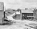 A 19th-century westerly view of one of the former grist mills (right) on the site of today's park

References[edit]
- ^ "Grist Mill Park". yarmouthcommservices. Retrieved May 18, 2024.
- ^ Royal River Corridor Study Y er Corridor Study Yarmouth, Maine Natur armouth, Maine Natural Resour al Resource Reconnaissance Surveys – University of Southern Maine (2008)
- ^ Royal River Corridor Master Plan – Yarmouth Town Council (2008)
- ^ The First Falls - Yarmouth's town website
- ^ Ancient North Yarmouth and Yarmouth, Maine 1636-1936: A History, William Hutchinson Rowe (1937)
- ^ Town of Yarmouth Open Space Plan 2019 – Royal River Conservation Trust