
Kumealon Inlet
| Kumealon Inlet | |
|---|---|
 | |
 Kumealon Inlet | |
| Location | British Columbia |
| Coordinates | 53°51′39″N 129°59′33″W / 53.86083°N 129.99250°W |
| Type | Fjord |
| Primary outflows | Grenville Channel |
Kumealon Inlet is an inlet on the Coast of British Columbia, Canada. It lies on the eastern side of the north end of Grenville Channel facing Pitt Island.[1]
Kumealon Inlet sits between the Ecstall Pluton and the Grenville Channel shear zone, and is bounded by rocks dating to the Albian (102.6±3.7Ma).[2]
Features[edit]
Connected features to the inlet are:
- Kumealon Island, located on the north side of the entrance to the inlet at 53°51′24″N 130°01′29″W / 53.85667°N 130.02472°W [3]
- Kumealon Lagoon, a small arm on the north side of the inlet at 53°53′03″N 129°59′20″W / 53.88417°N 129.98889°W,[4] connected to it via:
- Kumealon Narrows, a short narrows at 53°52′25″N 129°59′11″W / 53.87361°N 129.98639°W [5]
- Kumealon Creek, a short creek which feeds northwest into Kumealon Lagoon, entering it at 53°52′41″N 129°58′02″W / 53.87806°N 129.96722°W[6]
Images[edit]
Wikimedia Commons has media related to Kumealon Inlet.
-
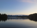 Looking westward from the head of Kumealon Inlet towards the entrance
 -
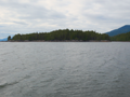 Kumealon Island
 -
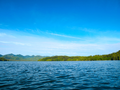 Looking westward along Kumealon Inlet in the morning


See also[edit]
References[edit]
- ^ BC Names/GeoBC entry "Kumealon Inlet"
- ^ Wolf D, Andronicos C, Vervoort J, Mansfield M, Chardon D (2010). "Application of Lu–Hf garnet dating to unravel the relationships between deformation, metamorphism and plutonism: An example from the Prince Rupert area, British Columbia". Tectonophysics. 485 (2010): 62–77. Bibcode:2010Tectp.485...62W. doi:10.1016/J.TECTO.2009.11.020.
- ^ BC Names/GeoBC entry "Kumealon Island"
- ^ BC Names/GeoBC entry "Kumealon Lagoon"
- ^ BC Names/GeoBC entry "Kumealon Narrows"
- ^ BC Names/GeoBC entry "Kumealon Creek"
This article about a location on the North Coast of British Columbia, Canada is a stub. You can help Wikipedia by expanding it. |