
Grimminghausen (Schmallenberg)
Grimminghausen | |
|---|---|
 | |
Location of Grimminghausen  | |
 Grimminghausen  Grimminghausen | |
| Coordinates: 51°13′11″N 8°12′38″E / 51.21972°N 8.21056°E | |
| Country | Germany |
| State | North Rhine-Westphalia |
| Admin. region | Arnsberg |
| District | Hochsauerlandkreis |
| Town | Schmallenberg |
| Population (2021-12-31) | |
| • Total | 52 |
| Time zone | UTC+01:00 (CET) |
| • Summer (DST) | UTC+02:00 (CEST) |
Grimminghausen is a locality in the municipality Schmallenberg in the district Hochsauerlandkreis in North Rhine-Westphalia, Germany.
Geography[edit]
The village has 52 inhabitants[1] and lies in the west of the municipality of Schmallenberg at a height of around 329 m on the Kreisstraße 38. The river Wenne flows through the village. Grimminghausen borders on the villages of Menkhausen, Lochtrop, Dorlar and Hengsbeck.
History[edit]
The first written document mentioning "Grimmardichusen" dates from 1282. The first chapel in the village was built around 1600. In 1900 was the new St. Peter and Paul Chapel built. The village used to belong to the municipality of Dorlar until the end of 1974.[2]
Gallery[edit]
-
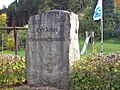 Stone 700 years Grimminghausen
 -
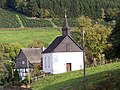 Chapel St. Peter and Paul, Anno 1900
 -
 Natural monument, English oak that characterizes the landscape
 -
 Aerial photograph of Grimminghausen
.jpg)

,_Naturdenkmal,_landschaftsbildpr%C3%A4gende_Stieleiche_(Quercus_robur).jpg)

References[edit]
- ^ Schmallenberg.de: Inhabitants (in German)
- ^ Statistisches Bundesamt (Hrsg.): Historisches Gemeindeverzeichnis für die Bundesrepublik Deutschland. Namens-, Grenz- und Schlüsselnummernänderungen bei Gemeinden, Kreisen und Regierungsbezirken vom 27.5.1970 bis 31.12.1982. W. Kohlhammer, Stuttgart/Mainz 1983, ISBN 3-17-003263-1, S. 335 f.
| Authority control databases: National |
|---|