
Al-Sarafiya Bridge
Al-Sarrafiya Bridge جسر الصرافية | |
|---|---|
 Al-sarrafiya bridge at night, June 2017 | |
| Coordinates | 33°21′13″N 44°22′22″E / 33.35361°N 44.37278°E |
| History | |
| Rebuilt | 27 May 2008 |
| Collapsed | 12 April 2007 |
| Location | |
 | |
The Al-Sarafiya Bridge (Arabic: جسر الصرافية) crosses the River Tigris in Baghdad, Iraq. It was built in the 1940s[1] or 1950s[2] and connected the two northern Baghdad neighborhoods of Waziriyah and Utafiyah.
Having been previously damaged by American bombing in 1991, the bridge partially collapsed when an abandoned truck bomb exploded on April 12, 2007 at 0700 local time, UTC+3.[1] At least 10 people were killed and 26 injured, though there were reports of 20 more trapped in cars that had gone off the bridge.[3]
The bridge was reconstructed in a year and two months and reopened on May 27, 2008, when former Prime Minister Nouri al-Maliki inaugurated it.[4]
Gallery[edit]
-
 Pilgrims Cross Over New Bridge in July, 2008
 -
 Pilgrims Cross Over the New Bridge in July, 2008
 -
 Crossing the Al-sarrafiya bridge in 2013
 -
Al-Sarafiya Bridge Lighting, June 2017
-
 Al-Sarafiya bridge 13 April 2007 after a truck bomb exploded on April 12, 2007
 -
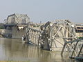 Al-Sarafiya bridge 13 April 2007 after a truck bomb exploded on April 12, 2007


References[edit]
- ^ a b "Explosion targets Baghdad bridge". BBC News. 2007-04-12. Retrieved 2007-08-02.
- ^ "Deadly blast damages Baghdad bridge". Al-Jazeera. 2007-04-12. Archived from the original on 2007-08-18. Retrieved 2007-08-02.
- ^ "Suicide truck bomb collapses Baghdad bridge". NBC News. 2007-04-12. Retrieved 2007-08-02.
- ^ "PM inaugurates al-Sarafiya bridge in Baghdad". Voices of Iraq. 2008-05-27. Retrieved 2008-05-27.[permanent dead link]
33°21′13″N 44°22′22″E / 33.35361°N 44.37278°E
This Baghdad-related article is a stub. You can help Wikipedia by expanding it. |
This article about a bridge in Iraq is a stub. You can help Wikipedia by expanding it. |
- Bridges in Iraq
- Buildings and structures in Baghdad
- Bridge disasters in Iraq
- Bridge disasters caused by warfare
- Bridge disasters caused by terrorism
- Bridges over the Tigris River
- Bridges completed in 2008
- 2007 disasters in Iraq
- April 2007 events in Iraq
- Iraq War sites in Baghdad
- Baghdad stubs
- Asian bridge (structure) stubs
- Iraqi building and structure stubs