
Aerodrom, Kragujevac
Aerodrom
Аеродром | |
|---|---|
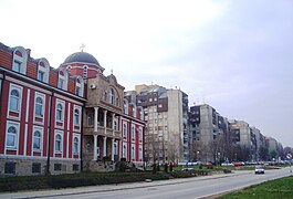
 Residential neighborhoods of Aerodrom | |
 Location of the municipality of Aerodrom within Serbia | |
| Coordinates: 44°01′57″N 20°54′18″E / 44.03250°N 20.90500°E | |
| Country | Serbia |
| Region | Šumadija and Western Serbia |
| District | Šumadija |
| Municipality | Kragujevac |
| Founded | 31 May 2002 |
| Dissolved | 4 March 2008 |
| Settlements | 17 |
| Area | |
| • Municipality | 232 km2 (90 sq mi) |
| Population (2002 census)[citation needed] | |
| • Urban | 23,249 |
| • Municipality | 36,217 |
| Time zone | UTC+1 (CET) |
| • Summer (DST) | UTC+2 (CEST) |
| Postal code | 34000 |
| Area code | +381(0)34 |
| Car plates | KG |
Aerodrom (Serbian Cyrillic: Аеродром; meaning Airport) was one of five city municipalities which constituted the City of Kragujevac. According to the 2002 census results, the municipality had a population of 36,217 inhabitants. The municipality was formed in May 2002, only to be dissolved in March 2008.
Municipality[edit]


The Municipality of Aerodrom covered the area of about 232 square kilometres, and comprised a part of urban Kragujevac and 17 villages:
Gallery[edit]
-
 The Cathedral of Saint Sava, Aerodrom, Kragujevac
 -
 School Seminary of Saint Jovan Zlatousti, Aerodrom, Kragujevac.
 -
 School Seminary of Saint Jovan Zlatousti, Aerodrom, Kragujevac.
 -
 Description City Market, Aerodrom, City of Kragujevac.
 -
 Lake of Šumarice


References[edit]
- ^ "Municipalities of Serbia, 2006". Statistical Office of Serbia. Retrieved 2010-11-28.
External links[edit]
Wikimedia Commons has media related to Aerodrom, Kragujevac.
This Šumadija District, Serbia location article is a stub. You can help Wikipedia by expanding it. |