
Proximity Park Historic District
Proximity Park Historic District | |
 Houses on Edgemont Road | |
  | |
| Location | Roughly bounded by Macon Ave., Howland Rd., Woodlink Rd., Charlotte St., and Sunset Trail, Asheville, North Carolina |
|---|---|
| Coordinates | 35°36′52″N 82°32′33″W / 35.61444°N 82.54250°W |
| Area | 31 acres (13 ha) |
| Built | 1907 |
| Architect | Richard Sharp Smith, et al. |
| Architectural style | Bungalow/craftsman, Colonial Revival, Spanish Colonial Revival |
| NRHP reference No. | 08000974[1] |
| Added to NRHP | October 8, 2008 |
Proximity Park Historic District is a national historic district located at Asheville, Buncombe County, North Carolina. The district encompasses 62 contributing buildings and 1 contributing site in a predominantly residential section of Asheville. The district was largely developed in early-20th century, and includes representative examples of Colonial Revival, Mission Revival, and Bungalow style dwellings. Located in the district is the separately listed St. Mary's Church (1914) and rectory (1923) designed by architect Richard Sharp Smith.[2]
It was listed on the National Register of Historic Places in 2008.[1]
Gallery[edit]
-
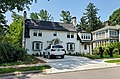
 40 Edgemont Road, 2021
 -
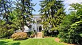
 55 Edgemont Road, 2021
 -
-
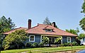 Golf Club House-C. C. Millard House, 2021
 -
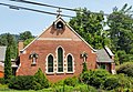 St. Marys Church, 2021


References[edit]
- ^ a b "National Register Information System". National Register of Historic Places. National Park Service. July 9, 2010.
- ^ Helen Purdum and Kathryn Scott (September 2006). "Proximity Park Historic District" (pdf). National Register of Historic Places - Nomination and Inventory. North Carolina State Historic Preservation Office. Retrieved August 1, 2014.

Categories:
- Houses on the National Register of Historic Places in North Carolina
- Historic districts on the National Register of Historic Places in North Carolina
- Colonial Revival architecture in North Carolina
- Mission Revival architecture in North Carolina
- Houses in Asheville, North Carolina
- National Register of Historic Places in Buncombe County, North Carolina
- Buncombe County, North Carolina Registered Historic Place stubs