Sunnersberg
Sunnersberg | |
|---|---|
Municipality | |
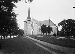
 Sunnersberg church (Photo by Anders Roland 20 February 2012) | |
| Coordinates: 58°34′0″N 13°7′0″E / 58.56667°N 13.11667°E | |
| Country | Sweden |
| County | Skaraborg County |
| Province | Västergötland |
| Time zone | UTC+1 (CET) |
| • Summer (DST) | UTC+2 (CEST) |
Sunnersberg Municipality was a municipality in the county of Skaraborg in Sweden.[1] The municipality was established in Sunnersberg parish in the Kålland district in Västergötland when the 1862 municipal regulations came into force. In the municipal reform of 1952 it became a commune in the North Kålland rural municipality, and in 1969 it was made part of Lidköping Municipality.[2] It lies on the south shore of Lake Vänern.
References[edit]
- ^ "Sunnersberg Map on Maplandia".
- ^ Andersson, Per (1993). Sveriges kommunindelning 1863–1993. Mjölby: Draking. ISBN 91-87784-05-X.

