
Ōiwayama Kofun Cluster
大岩山古墳群 | |
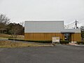
,_entrance.jpg) Entry to Kabutoyama Kofun | |
 Ōiwayama Kofun Cluster  Ōiwayama Kofun Cluster (Japan) | |
| Location | Yasu, Shiga, Japan |
|---|---|
| Region | Kansai region |
| Coordinates | 35°04′38″N 136°02′31″E / 35.07722°N 136.04194°E |
| Type | Kofun cluster |
| History | |
| Founded | 3rd to 6th century AD |
| Periods | Kofun period |
| Site notes | |
| Public access | Yes (no public facilities) |
The Ōiwayama Kofun Cluster (大岩山古墳群) is a group of Kofun to early Nara period burial mound cluster located in the Koshinohara neighborhood of the city of Yasu, Shiga in the Kansai region of Japan. It was designated a National Historic Site of Japan in 1941, wth the area under designation expanded in 1982, 1983 and 1995.[1]
Overview[edit]
The Ōiwayama Kofun Cluster is located in a fertile alluvial plain formed by the Yasu River. In 1881, 14 dōtaku were discovered on Mount Ōiwa, and ten more were found in two separate locations in 1962 during construction work on the tracks of the Tōkaidō Shinkansen. This was one of the largest concentrations of dōtaku which has been discovered, and to commemorate this find, Yasu city constructed the Dōtaku Museum (銅鐸博物館, Dōtaku Hakubutsukan) to display these artifacts, as well as others which have been found in other locations. These artifacts date from the late Yayoi period and the fact that they were buried intentionally was interpreted to be an indication of the unsettled political condition during the transition between the Yayoi and Kofun periods. The very large concentration was also interpreted to indicate that a large regional tribe or clan lived in this area, and this theory was supported by a large concentration of burial mounds in the flatlands surrounding Mount Ōiwa. [2]
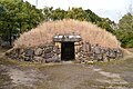
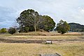
The Ōiwayama Kofun Cluster consists 17 confirmed tumuli, from the latter half of the 3rd century to the 6th century AD, or spanning the end of the Yayoi to the end of the Kofun period. Of these tumuli, the Maruyama Kofun (円山古墳), a "two conjoined rectangles" type (zenpō-kōhō-fun (前方後方墳)) and Kabutoyama Kofun (甲山古墳), a circular-type (empun (円墳)) which has the largest stone burial chamber in Shiga Prefecture, were designated as National Historic Sites in 1941. The Toba Kofun (冨波古墳), another zenpō-kōhō-fun was discovered in 1982 and added to the National Historic Site designation the same year. In 1985, six previously unknown tumuli were discovered and were also added to the area under protection, which then received the collective name of "Ōiwayama Kofun Cluster". The borders of the area under protection were adjusted in 1995. The site is now part of the Sakuraba-sama Historical Park, and is a short walk from the "Dotaku Museum Mae" bus stop on the Omi Railway bus from Yasu Station on the JR West Tōkaidō Main Line.[2] Artifacts uncovered during archaeological excavations have included bronze mirrors, earthenware, haniwa and Sue ware pottery.
| Kofun name | Coordinates | Type | Size | Date | Remarks |
|---|---|---|---|---|---|
| Toba Tumulus | 35°4′49.27″N 136°1′54.20″E / 35.0803528°N 136.0317222°E | zenpō-kōhō-fun | length 42 meters | 3rd century | oldest in the cluster |
| Kotobayama Kofun | 35°4′43.25″N 136°1′54.57″E / 35.0786806°N 136.0318250°E | enpun | dia 30m | late 3rd century | |
| Otsukayama Kofun | 35°4′38.60″N 136°2′30.65″E / 35.0773889°N 136.0418472°E | hotategai-gata | early 5th century | ||
| Kamezuka Kofun | 35°4′48.05″N 136°1′58.20″E / 35.0800139°N 136.0328333°E | hotategai-gata | length 45m | late 5th century | |
| Tennoyama Kofun | 35°4′25.10″N 136°2′24.37″E / 35.0736389°N 136.0401028°E | zenpō-kōen-fun | ength 50 meters | early 6th century | |
| Maruyama Kofun | 35°4′26.82″N 136°2′28.35″E / 35.0741167°N 136.0412083°E} | enpun | dia 28 meters | early 6th century | |
| Kabutoyama Kofun | 35°4′28.62″N 136°2′24.90″E / 35.0746167°N 136.0402500°E | enpun | dia 30 meters | mid 6th century | |
| Miyayama No. 2 Kofun | 35°4′24.60″N 136°2′41.30″E / 35.0735000°N 136.0448056°E | enpun | dia 15 meters | late 6th century |
Gallery[edit]
-
 Sakurabasama Historic Park
 -
 Kabutoyama Kofun sarcophagus
 -
 Kamezuka Kofun
 -
 Maruyama Kofun
 -
 Miyayama Kofun
 -
 Otsukayama Kofun
 -
 Tennoyama Kofun
 -
 Toba Kofun

,_genshitsu.jpg)

,_entrance.jpg)
-2,_funkyu-1.jpg)
,_zenpoubu.jpg)


See also[edit]
References[edit]
- ^ "大岩山古墳群" [Ōiwayama Kofun Cluster] (in Japanese). Agency for Cultural Affairs. Retrieved August 20, 2020.
- ^ a b Isomura, Yukio; Sakai, Hideya (2012). (国指定史跡事典) National Historic Site Encyclopedia. 学生社. ISBN 4311750404.(in Japanese)
External links[edit]
- Shiga Prefecture Department of Education (in Japanese)