
Poggiolo (stream)
| Poggiolo | |
|---|---|
 Mouth of the Poggiolo | |
  | |
| Location | |
| Country | France |
| Region | Corsica |
| Department | Haute-Corse |
| Physical characteristics | |
| Mouth | Tyrrhenian Sea |
• coordinates | 42°44′25″N 9°27′41″E / 42.7402°N 9.4613°E |
The Poggiolo (French: Ruisseau de Poggiolo, Corsican: Fiume di Poggiolu) is a small coastal stream in the department of Haute-Corse, Corsica, France. It enters the Tyrrhenian Sea from the east of the Cap Corse peninsula.
Course[edit]
The Poggiolo is 6.94 kilometres (4.31 mi) long and flows through the communes of San-Martino-di-Lota and Santa-Maria-di-Lota.[1] The stream rises in the Serra di Guagalone.[2] Its source is to the east of the 1,198 metres (3,930 ft) U Cimone. It flows south and then east past the village of Santa-Maria-di-Lota to enter the sea in the village of Miomo.[3] Its mouth is south of the Miomo pebble beach.[2]
For thirteen centuries the coasts of Corsica were at risk of being raided. The Genoese built a tower, the Torra di Miomu, near the mouth of the Poggiolu to guard its valley.[2]
Environment[edit]
-
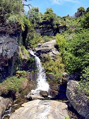
 Mandriale tributary
 -
 Poggiolo above the D31 bridge
 -
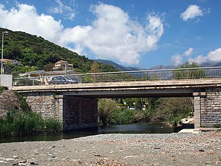 D80 bridge near the stream's mouth
 -
 Genoese Tour de Miomo north of the stream's mouth


The stream flows through a hilly schist landscape covered in thick maquis shrubland, with groves of green oaks (Quercus ilex). Along its banks there are ash trees, alders, hornbeams, hops and chestnut trees.[4] The stream is populated with brown trout (Salmo trutta).[5] The stream is in the Chenaies vertes du Cap Corse (Cap Corse green oaks) Zone naturelle d'intérêt écologique, faunistique et floristique (ZNIEFF).[6][7]
Tributaries[edit]
The following streams (ruisseaux) are tributaries of the Poggiolo:[1]
- Mandriale: 3 km (1.9 mi)
- Cavalligna: 3 km (1.9 mi)
Notes[edit]
Sources[edit]
- "Annexe 2-2" (PDF), Inventaire national du patrimoine naturel (INPN) (in French), MNHN & OFB, retrieved 2021-01-13
- Arrête n°2B-2020-11-12-005 (PDF) (in French), Préfet de la Haute-Corse, 12 November 2020, retrieved 2022-01-13
- Notre commune (in French), Commune de San-Martino-di-Lota, retrieved 2022-01-13
- "Relation: Ruisseau de Poggiolo (9423066)", OpenStreetMap, retrieved 2022-01-13
- "Ruisseau de Poggiolo", Sandre, retrieved 2021-01-13
- "San-Martino-di-Lota", Sites à visiter (in French), retrieved 2022-01-13
- "ZNIEFF 940004078 Chenaies vertes du Cap Corse", Inventaire national du patrimoine naturel (INPN) (in French), MNHN & OFB, retrieved 2022-01-13
| Waterbodies |
| ||||||||||||||||||||
|---|---|---|---|---|---|---|---|---|---|---|---|---|---|---|---|---|---|---|---|---|---|
| Rivers and streams |
| ||||||||||||||||||||

