
Hillsborough Forest
| Hillsborough Forest | |
|---|---|
 | |
| Map | |
 Location of Hillsborough forest | |
| Geography | |
| Location | Down, Northern Ireland, United Kingdom |
| Coordinates | 54°27′31″N 6°04′21″W / 54.4585°N 6.0726°W |
| Area | 500 acres (200 ha) |
| Administration | |
| Governing body | Forest Service Northern Ireland |
Hillsborough Forest is a mixed broadleaf and coniferous forest located near the village of Hillsborough in County Down, Northern Ireland. It was once part of the Hillsborough Castle demesne.[1] The lake located in the forest park contains brown trout and rainbow trout.[2][3]
The forest contains the remains of the Fox Fort rath.[4][5]
-
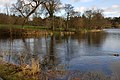 The lake, Hillsborough forest
 -
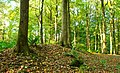 The earth bank shown is part of what remains of the rath


References[edit]
- ^ "Hillsborough Forest". nidirect.gov.uk. Retrieved 13 May 2018.
- ^ O'Reilly, Peter (1987). Trout and salmon loughs of Ireland: a fisherman's guide. Unwin. p. 14. ISBN 9780047990366.
- ^ Gerrard, David (2004). The Hidden Places of Ireland. Travel Publishing Ltd. p. 422. ISBN 9781904434108.
- ^ "Hillsborough, County Down". placenamesni.org. Retrieved 13 May 2018.
- ^ Lisburn & Castlereagh City Council. "Hillsborough Forest". visitlisburncastlereagh.com. Retrieved 13 May 2018.