
Battleford
Battleford | |
|---|---|
Town | |
 Post office in downtown Battleford | |
| Nicknames: "The Battlefords", "South Battleford" | |
 Battleford | |
| Coordinates: 52°44′18″N 108°18′55″W / 52.73833°N 108.31528°W[1] | |
| Country | Canada |
| Province | Saskatchewan |
| Census division | 12 |
| Rural Municipality | Battle River |
| Post office founded | 1877 |
| Incorporated (town) | 1904 |
| Government | |
| • Mayor | Ames Leslie |
| • CAO | Landon Chambers |
| • Governing body | Battleford Town Council |
| Area (2021)[2] | |
| • Land | 23.26 km2 (8.98 sq mi) |
| • Population Centre | 2.14 km2 (0.83 sq mi) |
| Population (2021)[2] | |
| • Total | 4,400 |
| • Density | 189.2/km2 (490/sq mi) |
| • Population Centre | 3,651 |
| • Population Centre density | 1,705.8/km2 (4,418/sq mi) |
| • National population rank (out of 5,008) | 867 |
| Time zone | UTC−06:00 (CST) |
| Postal code | S0M 0E0 |
| Area code | 306 |
| Highways | Highway 4 |
| Waterways | North Saskatchewan River Battle River |
| Website | www |
| [3][4] | |
Battleford (2021 population 4,400) is a town located across the North Saskatchewan River from the City of North Battleford, in Saskatchewan, Canada.
Battleford and North Battleford are collectively referred to as "The Battlefords" by Saskatchewan residents, as well as on highway signage. Although there has been occasional talk of the two communities merging, as of 2023 they remain separate entities. The local economy is fuelled mainly by agriculture. Battleford is bordered by the Rural Municipality of Battle River No. 438, as well as by the city of North Battleford and a small section of the Rural Municipality of North Battleford No. 437.
History[edit]
The Battleford area, dating from the 1770s, was the site of fur trading houses of numerous independent companies as well as the Hudson's Bay Company.[5] William Holmes[6] operated a trading post for the North West Company just above the confluence of the Battle and Saskatchewan rivers in 1784.[7] At least three posts were in use between 1868 and 1914.[8] The town was founded in 1875 as a fur trading post and North-West Mounted Police (NWMP) fort. Its post office opened in 1877.[9] Between 1876 and 1883, Battleford was the territorial capital of the North-West Territories (now Alberta, Saskatchewan, Nunavut, northern Quebec, northern Ontario and the Northwest Territories) and the NWMP fort (Fort Battleford) located there played an important role in the 1885 North-West Rebellion. It is also the terminus of the historic Swift Current-Battleford Trail.
In 1883, the Battleford Industrial School opened. A Canadian Indian residential school for First Nations children in Battleford, it operated from from 1883-1914. It was the first residential school operated by the Government of Canada with the aim of assimilating Indigenous people into the society of the settlers.
The school was one of three industrial schools opened by the Government of Canada in the early 1880s.[10]: 57 The senior officials of the Department of Indian Affairs arranged for various religious denominations to administer and operate the schools.[11] The federal government delegated responsibility for the Battleford school to an Anglican minister.[10]: 57
Looting of Battleford[edit]
On March 30, 1885, during the North-West Rebellion, the town of Battleford was looted by a party of Cree, who were short on food due to declining bison populations. When the Cree approached Battleford, the 500 residents[12] fled to the nearby North-West Mounted Police post, Fort Battleford. The Crees then took food and supplies from the abandoned stores and houses. Two people died during the looting. Crooked Leg was accused of killing John Payne, and Man Without Blood was accused of killing a farmer named Tremont. They were convicted of murder and hanged later that year.
Demographics[edit]
| Year | Pop. | ±% |
|---|---|---|
| 1901 | 609 | — |
| 1911 | 1,335 | +119.2% |
| 1921 | 1,229 | −7.9% |
| 1931 | 1,096 | −10.8% |
| 1941 | 1,336 | +21.9% |
| 1951 | 1,319 | −1.3% |
| 1961 | 1,627 | +23.4% |
| 1971 | 1,803 | +10.8% |
| 1981 | 3,565 | +97.7% |
| 1991 | 4,107 | +15.2% |
| 2001 | 3,820 | −7.0% |
| 2006 | 3,685 | −3.5% |
| 2011 | 4,065 | +10.3% |
| 2016 | 4,429 | +9.0% |
| 2021 | 4,400 | −0.7% |
| Source: Statistics Canada [2][13] | ||
In the 2021 Canadian census conducted by Statistics Canada, Battleford had a population of 4.400 living in 1,758 of its 1,877 total private dwellings, a change of -0.7% from its 2016 population of 4,429. With a land area of 23.26 km2 (8.98 sq mi), it had a population density of 189.2/km2 (489.9/sq mi) in 2021.[2]
The median age of the population in 2021 was 41.6, compared to the provincial figure of 38.8, and 79.6% were over the age of 15. The indigenous population was 23.9%, compared to 17.0% for Saskatchewan. Of the indigenous population, 52.9% were First Nations (Saskatchewan 64.5%), 43.1% were Métis (Saskatchewan 33.4%), and 3.4% gave other responses (Saskatchewan 2.1%).[2]
| 2021 | 2011 | |
|---|---|---|
| Population | 4,400 (-0.7% from 2016) | 4,065 (+10.3% from 2006) |
| Land area | 23.26 km2 (8.98 sq mi) | 23.33 km2 (9.01 sq mi) |
| Population density | 189.2/km2 (490/sq mi) | 174.2/km2 (451/sq mi) |
| Median age | 41.6 (M: 40.4, F: 42.4) | 40.6 (M: 39.9, F: 41.1) |
| Private dwellings | 1,877 (total) 1,758 (occupied) | 1,652 (total) |
| Median household income | $91,000 |
Historic buildings[edit]
National historic sites in Battleford include Fort Battleford National Historic Site of Canada,[18] Battleford Court House National Historic Site of Canada[19] and Old Government House / Saint-Charles Scholasticate National Historic Site of Canada. The Old Government House, built in 1878–1879, was destroyed by fire in 2003 and was the seat of Territorial Government from 1878 to 1883[20][21]
Other historic places in Battleford include the Battleford Land Registry Office built between 1877 and 1878 is the last remaining building on Battleford's Government Ridge that dates from the Territorial era.[22] Other heritage buildings include the District Court House,[23] the Town Hall / Opera House,[24] the Former Land Titles Building,[25] the Station Building,[26] the Fred Light Museum (St. Vital School),[27] St. Vital Church,[28] Gardiner Church[29] and the Former Bank of Montreal Building.[30]
-

-

-
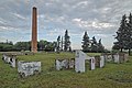 Remains of Old Government House
 -


Climate[edit]
Climate data is taken from North Battleford Airport located 5.41 km (3.36 mi) northeast of the town.[31]
North Battleford and the surrounding area experiences a humid continental climate (Köppen climate classification Dfb). The average high during the end of July is 24.6 °C (76.3 °F) and the average low is 11.3 °C (52.3 °F).[32] For the middle of January the average high is −12.3 °C (9.9 °F) and the average low is −22.6 °C (−8.7 °F).[33]
The highest temperature ever recorded in North Battleford was 39.5 °C (103.1 °F) on July 13, 2002.[34] The coldest temperature ever recorded was −51.7 °C (−61 °F) on February 1, 1893 and January 12, 1916.[35][36]
| Climate data for North Battleford (North Battleford Airport) WMO ID: 71876; coordinates 52°46′19″N 108°15′20″W / 52.77194°N 108.25556°W; elevation: 548.3 m (1,799 ft); 1991–2020 normals,[a] extremes 1879–present[b] | |||||||||||||
|---|---|---|---|---|---|---|---|---|---|---|---|---|---|
| Month | Jan | Feb | Mar | Apr | May | Jun | Jul | Aug | Sep | Oct | Nov | Dec | Year |
| Record high humidex | 10.7 | 10.1 | 19.3 | 30.0 | 36.9 | 41.5 | 42.9 | 40.7 | 36.9 | 30.0 | 19.3 | 10.4 | 42.9 |
| Record high °C (°F) | 10.8 (51.4) |
10.4 (50.7) |
19.3 (66.7) |
32.2 (90.0) |
34.9 (94.8) |
37.8 (100.0) |
39.5 (103.1) |
38.3 (100.9) |
36.5 (97.7) |
30.0 (86.0) |
19.5 (67.1) |
10.9 (51.6) |
39.5 (103.1) |
| Mean daily maximum °C (°F) | −10.1 (13.8) |
−7.8 (18.0) |
−1.2 (29.8) |
9.9 (49.8) |
18.0 (64.4) |
21.7 (71.1) |
24.3 (75.7) |
23.7 (74.7) |
18.5 (65.3) |
9.4 (48.9) |
−1.4 (29.5) |
−8.4 (16.9) |
8.1 (46.6) |
| Daily mean °C (°F) | −15.3 (4.5) |
−13.3 (8.1) |
−6.6 (20.1) |
3.3 (37.9) |
10.5 (50.9) |
15.1 (59.2) |
17.6 (63.7) |
16.6 (61.9) |
11.3 (52.3) |
3.3 (37.9) |
−6.3 (20.7) |
−13.4 (7.9) |
1.9 (35.4) |
| Mean daily minimum °C (°F) | −20.6 (−5.1) |
−18.9 (−2.0) |
−12.0 (10.4) |
−3.3 (26.1) |
3.0 (37.4) |
8.5 (47.3) |
10.8 (51.4) |
9.4 (48.9) |
4.1 (39.4) |
−2.8 (27.0) |
−11.1 (12.0) |
−18.4 (−1.1) |
−4.3 (24.3) |
| Record low °C (°F) | −46.1 (−51.0) |
−44.1 (−47.4) |
−38.4 (−37.1) |
−27.8 (−18.0) |
−13.2 (8.2) |
−2.9 (26.8) |
1.6 (34.9) |
−1.8 (28.8) |
−10.3 (13.5) |
−27.2 (−17.0) |
−35.8 (−32.4) |
−44.2 (−47.6) |
−46.1 (−51.0) |
| Record low wind chill | −55.3 | −54.6 | −48.2 | −35.8 | −16.4 | −5.4 | 0.0 | −3.9 | −14.0 | −29.6 | −41.1 | −51.7 | −55.3 |
| Average precipitation mm (inches) | 18.9 (0.74) |
14.2 (0.56) |
12.9 (0.51) |
25.0 (0.98) |
30.6 (1.20) |
60.1 (2.37) |
77.4 (3.05) |
50.7 (2.00) |
28.4 (1.12) |
20.4 (0.80) |
20.8 (0.82) |
23.8 (0.94) |
383.2 (15.09) |
| Average rainfall mm (inches) | 0.7 (0.03) |
0.4 (0.02) |
2.0 (0.08) |
17.2 (0.68) |
31.1 (1.22) |
65.0 (2.56) |
74.1 (2.92) |
57.9 (2.28) |
31.9 (1.26) |
9.0 (0.35) |
2.9 (0.11) |
0.4 (0.02) |
292.6 (11.52) |
| Average snowfall cm (inches) | 20.2 (8.0) |
12.7 (5.0) |
14.8 (5.8) |
9.6 (3.8) |
2.4 (0.9) |
0.0 (0.0) |
0.0 (0.0) |
0.0 (0.0) |
2.3 (0.9) |
8.2 (3.2) |
16.6 (6.5) |
17.5 (6.9) |
104.3 (41.1) |
| Average precipitation days (≥ 0.2 mm) | 12.2 | 10.1 | 8.6 | 9.8 | 9.0 | 13.0 | 12.9 | 9.9 | 7.7 | 8.3 | 11.4 | 12.8 | 125.6 |
| Average rainy days (≥ 0.2 mm) | 0.72 | 0.28 | 1.1 | 5.7 | 8.6 | 12.8 | 12.4 | 9.8 | 7.5 | 4.8 | 1.2 | 0.52 | 65.3 |
| Average snowy days (≥ 0.2 cm) | 10 | 7.2 | 7.1 | 3.8 | 0.88 | 0.08 | 0.0 | 0.0 | 0.58 | 3.0 | 7.5 | 9.5 | 49.6 |
| Average relative humidity (%) (at 1500 LST) | 72.8 | 71.6 | 66.1 | 46.8 | 38.4 | 48.0 | 51.0 | 47.5 | 45.2 | 53.5 | 70.2 | 74.4 | 57.1 |
| Source: Environment and Climate Change Canada[34][37][38] | |||||||||||||
Local media[edit]
- Newspaper
The local newspaper is The Battlefords News Optimist. It is published weekly on Thursday and has circulation in the surrounding area.
- Radio
Three local radio stations serve the area; CJNB, CJCQ-FM ("Q98"), and CJHD-FM ("93.3 Beach Radio[39]"). Some Saskatoon radio stations can also be received.
- Television
The Battlefords are served by CFQC-TV-2 channel 6, an analogue repeater of CTV station CFQC-DT Saskatoon.
In film[edit]
The 1973 western Alien Thunder was partially filmed in Battleford.
See also[edit]
Notes[edit]
- ^ Rain, snow, days with rain, and days with snow from 1981-2010 normals
- ^ Climate data was recorded in the city of Battleford from November 1879 to March 1942, and at North Battleford Airport from March 1942 to present.
References[edit]
- ^ "Battleford". Geographical Names Data Base. Natural Resources Canada.
- ^ a b c d e "Battleford, Town (T) Saskatchewan [Census subdivision] & Battleford Saskatchewan [Population centre] & Saskatchewan [Province]". Census Profile, 2021 Census of Population. Statistics Canada. February 1, 2023. Retrieved May 29, 2024.
- ^ National Archives, Archivia Net. "Post Offices and Postmasters". Archived from the original on 6 October 2006. Retrieved 6 September 2009.
- ^ Government of Saskatchewan, MRD Home. "Municipal Directory System". Archived from the original on 15 January 2016. Retrieved 6 September 2009.
- ^ Voorhis, Ernest (1930). "Historic Forts of the French Regime and of the English Fur Trading Companies". Historic Forts of the French Regime and of the English Fur Trading Companies. Govt. of Canada. Retrieved 2016-04-28.
- ^ Ray, Arthur. "William Holmes". Dictionary of Canadian Biography. University of Toronto/Universite Laval. Retrieved 2016-04-28.
- ^ Morton, Arthur (1973). A History of the Canadian West. University of Toronto Press. pp. 337 ff. ISBN 0-8020-4033-0.
- ^ Martz, Lawrence; et al. (2000). Atlas of Saskatchewan (CD ed.). Saskatoon: University of Saskatchewan. Map of Trading Posts pre 1759 – post 1930.
- ^ "Battleford". Encyclopedia of Saskatchewan. Canadian Plains Research Center, University of Regina. 2006. Archived from the original on 2007-12-31. Retrieved 2013-12-08.
- ^ a b Honouring the truth, reconciling for the future : summary of the final report of the Truth and Reconciliation Commission of Canada (PDF). Winnipeg, Manitoba: National Centre for Truth and Reconciliation, University of Manitoba. 2015. ISBN 978-0-660-02078-5. Retrieved June 13, 2021.
- ^ Wasylow, Walter Julian (1972). History of Battleford Industrial School for Indians (MA). University of Saskatchewan. p. 56. Retrieved 13 June 2021.
- ^ Henry Thomas McPhillips (1888), McPhillips' alphabetical and business directory of the district of Saskatchewan, N.W.T.: Together with brief historical sketches of Prince Albert, Battleford and the other settlements in the district, 1888 (p. 53), Prince Albert, NWT: Henry Thomas McPhillips
- ^ "Battleford, Town [Census subdivision], Saskatchewan and Division No. 12, Census division [Census division], Saskatchewan". Census Profile, 2016 Census. Statistics Canada. October 27, 2021. Retrieved May 29, 2024.
- ^ "2021 Community Profiles". 2021 Canadian Census. Statistics Canada. February 4, 2022. Retrieved 2023-10-19.
- ^ "2011 Community Profiles". 2011 Canadian Census. Statistics Canada. March 21, 2019. Retrieved 2013-12-09.
- ^ "2006 Community Profiles". 2006 Canadian Census. Statistics Canada. August 20, 2019.
- ^ "2001 Community Profiles". 2001 Canadian Census. Statistics Canada. July 18, 2021.
- ^ Fort Battleford. Canadian Register of Historic Places. Retrieved 2013-12-07.
- ^ Battleford Court House. Canadian Register of Historic Places. Retrieved 2013-12-07.
- ^ Old Government House / Saint-Charles Scholasticate. Canadian Register of Historic Places. Retrieved 2013-12-07.
- ^ Government House, Battleford. Canadian Register of Historic Places. Retrieved 2013-12-07.
- ^ Battleford Land Registry Office. Canadian Register of Historic Places. Retrieved 2013-12-07.
- ^ District Court House. Canadian Register of Historic Places. Retrieved 2013-12-07.
- ^ Town Hall / Opera House. Canadian Register of Historic Places. Retrieved 2013-12-07.
- ^ Former Land Titles Building. Canadian Register of Historic Places. Retrieved 2013-12-07.
- ^ The Station Building. Canadian Register of Historic Places. Retrieved 2013-12-07.
- ^ Fred Light Museum (St. Vital School). Canadian Register of Historic Places. Retrieved 2013-12-07.
- ^ St. Vital Church. Canadian Register of Historic Places. Retrieved 2013-12-07.
- ^ Gardiner Church. Canadian Register of Historic Places. Retrieved 2013-12-07.
- ^ Former Bank of Montreal Building. Canadian Register of Historic Places. Retrieved 2013-12-07.
- ^ "1991-2020 Canadian Climate Normals Locations". Environment and Climate Change Canada. March 27, 2023. Retrieved May 29, 2024.
- ^ "Climate Data Almanac for July 31". Environment and Climate Change Canada. October 31, 2011. Retrieved October 20, 2012.
- ^ "Climate Data Almanac for January 10". Environment and Climate Change Canada. October 31, 2011. Retrieved October 20, 2012.
- ^ a b "Canadian Climate Normals 1991-2020 Data". Environment and Climate Change Canada. 2024-03-27. Retrieved 2024-05-29.
- ^ "February 1893". Environment and Climate Change Canada. 31 October 2011. Retrieved 30 April 2016.
- ^ "January 1916". Environment and Climate Change Canada. 31 October 2011. Retrieved 30 April 2016.
- ^ "Canadian Climate Normals 1981-2010". Environment and Climate Change Canada. 2024-03-27. Retrieved 2024-05-29.
- ^ "Daily Data Report for September 2022". Canadian Climate Data. Environment and Climate Change Canada. 2011-10-31. Retrieved 2022-09-05.
- ^ Staff, battlefordsNOW. "CJHD transitions to endless summers as 93.3 BEACH RADIO". battlefordsNOW. Retrieved 2023-08-27.
Places adjacent to Battleford | |
|---|---|
| International | |
|---|---|
| National | |
| Geographic | |