Lindsay Reef

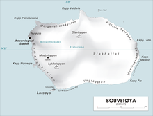
Lindsay Reef (54°26′S 3°29′E / 54.433°S 3.483°E) is a reef lying close north of Cape Meteor on the east side of the island of Bouvetøya in the South Atlantic Ocean. The reef was first charted in 1898 by a German expedition under Carl Chun. It was recharted in December 1927 by a Norwegian expedition under Captain Harald Horntvedt, and named by the Norwegians after Captain James Lindsay, a British whaler in command of the Swan who, in the company of Captain Thomas Hopper with the Otter, sighted Bouvetøya in 1808.[1][2]
References[edit]
- ^ "Lindsay Reef". Geographic Names Information System. United States Geological Survey, United States Department of the Interior. Retrieved 2013-06-17.
- ^ "Prof. Dr. phil., Dr. med. h. c. Carl Chun". University of Leipzig. Retrieved October 1, 2016.
Other sources[edit]
- Simpson-Housley, Paul (2002) Antarctica: Exploration, Perception and Metaphor (Routledge) ISBN 9781134891214
![]() This article incorporates public domain material from "Lindsay Reef". Geographic Names Information System. United States Geological Survey.
This article incorporates public domain material from "Lindsay Reef". Geographic Names Information System. United States Geological Survey.
