
Puerto Rico Highway 819
Highway 819 | ||||
|---|---|---|---|---|
| Ruta 819 | ||||
| Route information | ||||
| Maintained by Puerto Rico DTPW | ||||
| Length | 4.2 km[1] (2.6 mi) | |||
| Major junctions | ||||
| South end | ||||
| North end | ||||
| Location | ||||
| Country | United States | |||
| Territory | Puerto Rico | |||
| Municipalities | Toa Alta, Toa Baja | |||
| Highway system | ||||
| ||||

Puerto Rico Highway 819 (PR-819) is a north–south rural road located between the municipalities of Toa Alta and Toa Baja in Puerto Rico.[2] With a length of 4.2 kilometers (2.6 mi), it begins at PR-861 on the Ortiz–Mucarabones line in Toa Alta, and ends at PR-863 in Candelaria barrio in Toa Baja.[3]
Route description[edit]
Due to its rural characteristics, PR-819 has a single lane per direction in the entire length. In Toa Alta, this highway extends from its southern terminus at PR-861 junction between Ortiz and Mucarabones barrios to the Toa Baja municipal limit,[4] passing through several neighborhoods and crossing the Río Bucarabones in Mucarabones.[5] In Toa Baja, the road continues to the north through Candelaria barrio, where it also serves as the main access to several neighborhoods, extending from the Toa Alta municipal limit to the northern terminus at PR-863 junction.[6]
-
 Sign for PR-819 in Mucarabones, Toa Alta, looking north
 -
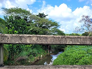 Bucarabones River from PR-819 bridge


Major intersections[edit]
-
 PR-819 south near PR-861 junction in Mucarabones, Toa Alta
 -
 PR-819 south at PR-861 junction in Toa Alta
 -
 PR-861 west at PR-819 junction in Toa Alta
 -
 Signs for PR-863 at the northern terminus of PR-819 in Candelaria, Toa Baja
.jpg)
.jpg)


| Municipality | Location | km[1] | mi | Destinations | Notes |
|---|---|---|---|---|---|
| Toa Alta | Ortíz–Mucarabones line | 0.0 | 0.0 | Southern terminus of PR-819; access to Toa Alta and Bayamón | |
| Toa Baja | Candelaria | 4.2 | 2.6 | Northern terminus of PR-819; access to Toa Baja and Bayamón | |
| 1.000 mi = 1.609 km; 1.000 km = 0.621 mi | |||||
See also[edit]
References[edit]
- ^ a b Google (29 February 2020). "PR-819" (Map). Google Maps. Google. Retrieved 29 February 2020.
- ^ National Geographic Maps (2011). Puerto Rico (Map). 1:125,000. Adventure Map (Book 3107). Evergreen, Colorado: National Geographic Maps. ISBN 978-1566955188. OCLC 756511572.
- ^ "Tránsito Promedio Diario (AADT)". Transit Data (Datos de Transito) (in Spanish). DTOP PR. p. 130. Archived from the original on 1 April 2019.
- ^ "PR-819, Toa Alta, Puerto Rico". pr.geoview.info. Retrieved 7 February 2020.
- ^ Press, Detroit Free. "PR 819 over BUCARABONES RIVER Toa Alta Municipio, Puerto Rico Bridge Inspection Report". Detroit Free Press. Retrieved 14 August 2023.
- ^ "PR-819, Toa Baja, Puerto Rico". pr.geoview.info. Retrieved 7 February 2020.
External links[edit]
 Media related to Puerto Rico Highway 819 at Wikimedia Commons
This Puerto Rican location article is a stub. You can help Wikipedia by expanding it. |
This Puerto Rico road-related article is a stub. You can help Wikipedia by expanding it. |