Abel Island
Native name: Abeløya | |
|---|---|
| Geography | |
| Coordinates | 78°59′20″N 30°12′20″E / 78.98889°N 30.20556°E |
| Area | 13 km2 (5.0 sq mi) |
| Administration | |
Norway | |

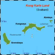
Abel Island[1][2][3] (Norwegian: Abeløya) is an island in Svalbard. It is the third-largest island of Kong Karls Land with an area of 13 km2 (5.0 sq mi). It is named after the Norwegian mathematician Niels Henrik Abel.[4] Abel Island is separated from Kongsøya by the strait Lydiannasundet.[5]
References[edit]
- ^ Churchill, Robin R. 2001. Claims to Maritime Zones in the Arctic—Law of the Sea Normality or Polar Peculiarity? In Alex G. Oude Elferink & Donald R. Rothwell (eds.), The Law of the Sea and Polar Maritime Delimitation and Jurisdiction, pp. 105–124. The Hague: Martinus Nijhoff Publishers, p. 120.
- ^ Symmons, Clive R. 2014. Maritime Zones from Islands and Rocks. In S. Jayakumar, Tommy Koh, & Robert Beckman (eds.), The South China Sea Disputes and Law of the Sea, pp. 55–120. Cheltenham, UK: Edward Elgar, p. 101.
- ^ Mills, William James. 2003. Exploring Polar Frontiers: A Historical Encyclopedia. Volume 1: A–L. Santa Barbara, CA: ABC Clio, p. 348.
- ^ "Abeløya (Svalbard)". Norwegian Polar Institute. Archived from the original on 4 December 2014. Retrieved 10 July 2013.
- ^ "Lydiannasundet (Svalbard)". Norwegian Polar Institute. Archived from the original on 4 December 2014. Retrieved 10 July 2013.

