
Grand View Spire
| Grand View Spire | |
|---|---|
 East aspect | |
| Highest point | |
| Elevation | 5,821 ft (1,774 m)[1] |
| Prominence | 161 ft (49 m)[1] |
| Parent peak | Black Ridge[2] |
| Isolation | 2.21 mi (3.56 km)[2] |
| Coordinates | 39°05′28″N 108°43′22″W / 39.09105°N 108.722742°W[1] |
| Geography | |
 Grand View Spire Location in Colorado  Grand View Spire Grand View Spire (the United States) | |
| Location | Colorado National Monument Mesa County, Colorado, U.S. |
| Parent range | Colorado Plateau Uncompahgre Plateau[1] |
| Topo map | USGS Colorado National Monument |
| Geology | |
| Age of rock | Late Triassic to Early Jurassic[3] |
| Type of rock | Wingate Sandstone |
| Climbing | |
| First ascent | 1961[4] |
| Easiest route | class 5.8 A2 climbing[2] |
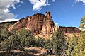
Grand View Spire is a 5,821-foot-elevation (1,774-meter) sandstone pillar located in Colorado National Monument, in Mesa County of western Colorado, United States. This 400-foot tower is situated on the west side of Monument Canyon, one mile southeast of the monument's visitor center, and 9 miles (14 km) west of the community of Grand Junction. It is also 0.32 mile immediately south of Independence Monument, and 0.27 mile northwest of another climbing destination, Kissing Couple.[1] Its unofficial name relates to its position at the tip of Grand View Overlook, one of several scenic viewpoints along Rim Rock Drive.[5]
Geology[edit]
The spire is composed primarily of cliff-forming Wingate Sandstone, which consists of wind-borne, cross-bedded quartzose sandstones deposited as ancient sand dunes approximately 200 million years ago in the Late Triassic. The caprock at the summit consists of fluvial sandstones of the resistant Kayenta Formation. The slope around the base of Grand View Spire is Chinle Formation.[6] The floor of the canyon is Precambrian basement rock consisting of gneiss, schist, and granites. Precipitation runoff from this geographical feature drains to the Colorado River, approximately three miles to the northeast.
Climate[edit]
According to the Köppen climate classification system, Grand View Spire is located in a semi-arid climate zone.[7] Summers are hot and dry, while winters are cold with some snow. Temperatures reach 100 °F (38 °C) on 5.3 days, 90 °F (32 °C) on 57 days, and remain at or below freezing on 13 days annually. The months April through October offer the most favorable weather to visit.
Climbing[edit]
Established rock climbing routes on Grand View Spire:[8]
- Southwest Defile Route – class 5.8 C2 – 3 pitches – First ascent 1961 by John Auld, John Kuglin, Gary Ziegler[9]
- Relics – class 5.10 – 5 pitches – FA November 13, 1991, by Mike Baker, Michael Kennedy, Bob Wade[10]
See also[edit]
Gallery[edit]
-
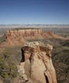 Grand View Spire in foreground as seen from Grand View Overlook.
("The Island" in the distance.) -
 Grand View Spire centered, with Independence Monument to right
 -
 Egypt Rock (left), Kissing Couple (center), Grand View Spire (right)
as seen from Monument Canyon -
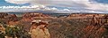 Grand View overlook.
L to R: Independence Monument, The Island, Grand View Spire, Kissing Couple. -
 Grand View Spire in foreground as seen from Grand View Overlook
 -


References[edit]
- ^ a b c d e "Grandview Spire, Colorado". Peakbagger.com. Retrieved 2021-03-28.
- ^ a b c "Grand View Spire - 5,821' CO". listsofjohn.com. Retrieved 2021-03-28.
- ^ Geologic Formations, National Park Service
- ^ Jeff Achey, 2002, Climb! The History of Rock Climbing in Colorado, The Mountaineers Books, page 125.
- ^ "Grand View". Geographic Names Information System. United States Geological Survey, United States Department of the Interior. Retrieved 2021-03-28.
- ^ Stanley William Lohman, The Geologic Story of Colorado National Monument, Geological Survey Bulletin 1508, pages 28-30.
- ^ Peel, M. C.; Finlayson, B. L.; McMahon, T. A. (2007). "Updated world map of the Köppen−Geiger climate classification". Hydrol. Earth Syst. Sci. 11. ISSN 1027-5606.
- ^ Grand View Spire Rock Climbing, Mountain Project
- ^ Jeff Achey, 2002, Climb! The History of Rock Climbing in Colorado, The Mountaineers Books, page 125.
- ^ Cameron Burns, Selected Climbs in the Desert Southwest: Colorado and Utah, 1999, Mountaineers Books, ISBN 9780898866575, page 32.
External links[edit]
- Weather forecast: National Weather Service
- Grand View Spire rock climbing: Mountainproject.com