
Loch Clair
| Loch Clair | |
|---|---|
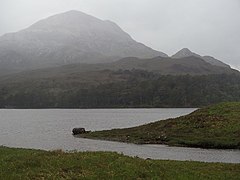
.jpg) Loch Clair for the southern end | |
 Loch Clair Location in Wester Ross | |
| Location | NG99905723 |
| Coordinates | 57°33′40″N 5°20′43″W / 57.561020°N 5.345385°W |
| Type | freshwater loch |
| Basin countries | Scotland |
| Max. length | 0.55 km (0.34 mi)[1] |
| Max. width | 0.19 km (0.12 mi)[1] |
| Surface area | 63 ha (160 acres)[2] |
| Average depth | 41.9 ft (12.8 m)[1] |
| Max. depth | 92.8 ft (28.3 m)[1] |
| Water volume | 284,686,148.7 cu ft (8,061,414.00 m3)[1] |
| Shore length1 | 5 km (3.1 mi) [2] |
| Surface elevation | 94 m (308 ft)[2] |
| Max. temperature | 57 °F (14 °C) |
| Min. temperature | 48 °F (9 °C) at 85 feet[1] |
| 1 Shore length is not a well-defined measure. | |
Loch Clair is a small remote shallow low-altitude freshwater loch, located within the Coulin Forest, some three miles to the south-west of Kinlochewe in Wester Ross.[1][2] Loch Clair is the lower of two lochs in the same valley, and aligned on a southeast–northwest bearing. The other loch is Loch Coulin[3] that is fed by the River Coulin, the waters of which in turn flow out of Loch Coulin through a short unnamed river into Loch Clair. A small lochan, Loch Bharranch,[4] is located a mile to the west and drains into the western end of Loch Clair through an unnamed burn.
Loch Clair is drained by another river, A' Ghairbhe, which flows in a roughly north-east direction to Kinlochewe, where it joins the Abhainn Bruachaig to form the Kinlochewe River.
Loch Clair can be reached by the A896 road, which runs from Kinlochewe to Torridon, Shieldaig and beyond.
Geography[edit]
Loch Clair is bounded to the north by a mountain massif in the Torridon area that contains the highest peak of Beinn Eighe, that is within Beinn Eighe National Nature Reserve.[5][6] The imposing peak of Liathach at 1024 metres is the most prominent peak that is visible from Loch Clair.[4] To the west, the loch is bounded by a series of low hills, the highest two being Creag Dhubh at 384 metres and Sgùrr Dubh at 782 metres.[7] To the east is open peatland in an area consisting of small hills, burns and peat bogs. To the south is a continuation of the mountainous Coulin Forest, with Meall an Leathaid Mhòir at altitude 512 metres.
Fishing[edit]
Loch Clair is an excellent fishing location for trout that weigh 10 to 12 ounces.[8] Ideal trout flies for the loch include Soldier Palmer, Greenwell's Glory and Silver Butcher.[8]
Walking[edit]
Loch Clair is the location of an almost level hiking route that follows the north coast of the loch, before making a circular walk around Loch Coulin and is about 9.64 km long.[9]
Gallery[edit]
-
 Loch Clair and Sgurr Dubh
 -
 Another view of Loch Clair and Sgurr Dubh
 -
 Loch Clair viewed from the north
 -
 Loch Clair With Liathach forming the backdrop.


References[edit]
- ^ a b c d e f g John, Murray; Lawrence, Pullar. Bathymetrical Survey of the Fresh-Water Lochs of Scotland, 1897–1909 Lochs of the Ewe Basin Volume II – Loch Clair. p. 222.
 This article incorporates text from this source, which is in the public domain.
- ^ a b c d "Loch Garbhaig". Centre for Ecology and Hydrology. Scotland and Northern Ireland Forum for Environmental Research (SNIFFER). Retrieved 28 April 2024.
- ^ "Loch Coulin". Centre for Ecology and Hydrology. Scotland and Northern Ireland Forum for Environmental Research (SNIFFER). Retrieved 28 April 2024.
- ^ a b Sandison, Bruce (1997). Trout & Salmon Rivers and Lochs of Scotland. Ludlow: Stackpole Books. p. 255. ISBN 978-1-873674-31-4.
- ^ Murphy, Alan (22 March 2013). Northwest Highlands of Scotland Footprint Focus Guide: Includes Inverness, Fort William, Glen Coe & Ullapool. Bath: Footprint Travel Guides. p. 103. ISBN 978-1-909268-24-1.
- ^ "The Story of Beinn Eighe National Nature Reserve" (PDF). The Story of Beinn Eighe National Nature Reserve. Kinlochewe: Scottish Natural Heritage (Now NatureScot). Retrieved 28 April 2024.
- ^ "walkhighlands Sgurr Dubh". walkhighlands.co.uk. Archived from the original on 28 April 2024. Retrieved 28 April 2024.
- ^ a b Sandison, Bruce (1997). Trout & Salmon Rivers and Lochs of Scotland. Ludlow: Stackpole Books. p. 208. ISBN 978-1-873674-31-4.
- ^ "Hiking: Loch Clair and Loch Coulin". Open Street Maps Routes. OS Maps. Retrieved 28 April 2024.