
Kasperi, Seinäjoki
Kasperi | |
|---|---|
District of Seinäjoki | |
 Houses in Kasperi | |
| Coordinates: 62°46′12″N 22°52′37″E / 62.770°N 22.877°E | |
| Country | |
| Region | Southern Ostrobothnia |
| City | Seinäjoki |
| Population (2022) | |
| • Total | 3,759 |
| includes Hallilanvuori | |
Kasperi is a district and a suburb (lähiö) of Seinäjoki, Finland. It is located about four kilometers to the southeast from the city center.[1] Kasperi is a part of the Kasperi ward, which also includes the eastern Kivistö and Hallilanvuori sub-districts.[2] Local services include a school, a supermarket, a pub and a dentist office.[1][3]
In 2022, the population of Kasperi (including Hallilanvuori) was 3,759.[4]
History[edit]
Kasperi was mostly built during the 1970s and 1980s.[5] The designing of the neighborhood was inspired by the Tapiola district of Espoo. Kasperi was named after Kasperi Kustaa's Kasperi-building which was located in the area.[1][6]
Later, the Hallilanvuori residential area was built next to a mountain of the same name in southern Kasperi.[7]
Gallery[edit]
-
 An apartment building on the street Tapiolantie.
 -
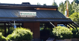 Toimintojen Talo, a local cafeteria with other services.
 -
 A laavu in Hallilanvuori.
 -
 Local services.


References[edit]
- ^ a b c "Alue". SKV Kiinteistönvälitys. Retrieved 2017-09-03.
- ^ Tietoa Taskuun (pdf)
- ^ "Seinäjoen kaupungin karttapalvelu". kartat.seinajoki.fi. Retrieved 2017-09-03.
- ^ Peltokangas, Heikki (2023-05-28). "Seinäjoen asukasluku pullistelee yllättävästi – Katso kartalta, kuuluuko kaupunginosasi kasvajiin vai kuihtujiin". ilkkapohjalainen.fi (in Finnish). Retrieved 2023-07-09.
- ^ En kehu, mutta tulipahan sekin taas tehtyä (pdf)
- ^ Oy, I-Mediat. "Murhavuoresta Karhuvuori". Pohjalainen (in Finnish). Retrieved 2017-09-07.
- ^ "Seinäjoen kaupungin karttapalvelu". kartat.seinajoki.fi. Retrieved 2023-07-09.