
Stoney Creek (Delaware)
| Stony Creek Tributary to Delaware River | |
|---|---|
 Stenkill Falls along Stony Creek | |
 Location of Stony Creek Mouth  Stoney Creek (Delaware) (the United States) | |
| Location | |
| Country | United States |
| State | Delaware |
| County | New Castle |
 | |
| Physical characteristics | |
| Source | Perkins Run divide |
| • location | Westwood, Delaware |
| • coordinates | 39°48′18″N 075°30′07″W / 39.80500°N 75.50194°W[1] |
| • elevation | 340 ft (100 m)[2] |
| Mouth | Delaware River |
• location | Bellevue, Delaware |
• coordinates | 39°46′26″N 075°28′48″W / 39.77389°N 75.48000°W[1] |
• elevation | 0 ft (0 m)[2] |
| Length | 4.7 mi (7.6 km)[3] |
| Basin size | 2.36 square miles (6.1 km2)[4] |
| Discharge | |
| • average | 3.37 cu ft/s (0.095 m3/s) at mouth with Stenkil Creek[4] |
| Basin features | |
| Progression | southeast |
| River system | Delaware River |
| Tributaries | |
| • left | Fox Run (Delaware) (Flows through Forwood Preserve), Jacksons Creek (Delaware) (Meets Stony Creek in Carcroft Crest Park, Boulder Run (Delaware) flows through Bellevue State Park. |
| • right | Kallved Creek (Delaware) Name has Swedish origins, “kall” meaning cold and “ved” meaning wood. |
| Waterbodies | Bellevue Lake |
| Waterfalls | Stenkill Falls and Tukohtene Falls |
| Bridges | Marsh Road (Delaware Route 3) Veale Road Silverside Road I-95 Carr Road Philadelphia Pike US 13 I-495 |
Stoney Creek is a 2.76 mi (4.44 km) long second order tributary to the Delaware River in New Castle County, Delaware.
Variant names[edit]
According to the Geographic Names Information System, it has also been known historically as:[1][5]
- Fransens Creek
- Oele Fransens Creek
- Tukohtene Creek
- Quarry Creek
- Quarryville Creek
- Stenkill Creek
- Stony Creek
Course and dam[edit]
Stoney Creek rises on the Perkins Run divide in Westwoods in New Castle County, Delaware and flows southeast to mouth at the Delaware River just north of Fox Point State Park.[2] It passes through in Bellevue State Park.[6] Tukohtene Falls (Lenape for round mountain) is a ten-foot waterfall located in the park.
Bellevue Lake is a reservoir created by the impounding of Stoney Creek in 1936.[7] it has a capacity of 100 millions gallons of water.[8] Bellevue Lake is a remnant of the Old Bellevue Quarry,[9] which was allowed to fill.[10] (The harvested stone was used to build the Delaware Breakwater[11]) It is 0.2 miles (0.32 km) miles across[12] and covers 11 acres (4.5 ha). The reservoir supplied the Wilmington and Suburban Water Comopany, which was founded in 1933 and has since absorbed into Suez Water.[13]
-
 Boulder Run entering Bellevue Lake
 -
 Bellevue Lake Dam
 -


.jpg)
Watershed[edit]
Stony Creek has a stream segment length of 1 km. Its watershed drains 2.36 square miles (6.1 km2) of area, receives about 46.8 inches (119 cm) of precipitation per year and 24 inches of snow annually. It has a topographic wetness index of 475.50, is about 17.6% forested, and a mean temperature of 12.5 °C (54.5 °F). Located in the deciduous and mixed forests. It is one of four major streams that empty into the Delaware River from the Piedmont in Delaware, the others are Shellpot Creek, Perkins Run and Naamans Creek.[4]
Images[edit]
-
 Tukohtene Falls
 -
 Stony Creek (February 2019)
 -
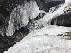 Stenkill Falls
 -
 Stenkill Falls flooded
 -
 Near Allen Tract Park
 -
 Rocks in Carcroft Crest Park


.jpg)


See also[edit]
References[edit]
- ^ a b c "GNIS Detail - Stenkil Creek". geonames.usgs.gov. US Geological Survey. Retrieved 27 February 2020.
- ^ a b c "Stony Creek Topo Map, New Castle County DE (Marcus Hook Area)". TopoZone. Locality, LLC. Retrieved 27 February 2020.
- ^ "ArcGIS Web Application". epa.maps.arcgis.com. US EPA. Retrieved 27 February 2020.
- ^ a b c "Stony Creek Watershed Report". Waters Geoviewer. US EPA. Retrieved 27 February 2020.
- ^ *Indigenous, European, and American Place Names of Streams and Waterways in Delaware (PDF) (Report). University of Delaware. 2021.
- ^ Parks, Delaware State. "Bellevue". Delaware State Parks.
- ^ Engineers, United States Army Corps of (March 31, 1975). "National program of inspection of dams". [Department of Defense], Department of the Army, Office of the Chief of Engineers – via Google Books.
- ^ William Charles Rasmussen, John W. Odell, Norman Howard Beamer (1966), Delaware Water Geological Survey (water-supply paper), U.S. Department of the Interior, Geological Survey
{{citation}}: CS1 maint: multiple names: authors list (link) - ^ Federal Writers' Project (2013), The WPA Guide to Delaware: The First State, Trinity University Press (reprint), p. 324, ISBN 9781595342072
- ^ Dunlap, Gertrude F. (April 30, 1992). Fox Point Remembered: Early Development in New Castle, Delaware. DIANE Publishing. ISBN 9780941375498 – via Google Books.
- ^ "Memories of Fox Point Historical Marker". www.hmdb.org.
- ^ L. W. HECK, A. J. WRAIGHT, D. J. ORTH, J. R. CARTER, L. G. VAN WINKLE, and JANET HAZEN (1966). Delaware Place Names (PDF). Geological Survey Bulletin 1245 (Report). Government Printing Office (U.S.A.). p. 14.
{{cite report}}: CS1 maint: multiple names: authors list (link) - ^ "Local projects". Suez. Retrieved March 30, 2022.