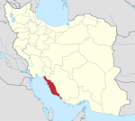
Kuri Rural District
Kuri Rural District
Persian: دهستان كورئ | |
|---|---|
| Coordinates: 27°54′37″N 52°15′55″E / 27.91028°N 52.26528°E[1] | |
| Country | Iran |
| Province | Bushehr |
| County | Jam |
| District | Central |
| Capital | Kuri Hayati |
| Population (2016)[2] | |
| • Total | 4,512 |
| Time zone | UTC+3:30 (IRST) |
Kuri Rural District (Persian: دهستان كورئ) is in the Central District of Jam County, Bushehr province, Iran. Its capital is the village of Kuri Hayati.[3]
At the census of 2006, its population was 3,309 in 711 households.[4] There were 3,689 inhabitants in 951 households at the following census of 2011.[5] In the most recent census of 2016, the population of the rural district was 4,512 in 1,203 households. The most populous of its 16 villages was Kuri Hayati, with 1,136 people.[2]
References[edit]
- ^ OpenStreetMap contributors (31 March 2023). "Kuri Rural District (Jam County)" (Map). OpenStreetMap. Retrieved 31 March 2023.
- ^ a b "Census of the Islamic Republic of Iran, 1395 (2016)". AMAR (in Persian). The Statistical Center of Iran. p. 18. Archived from the original (Excel) on 3 August 2017. Retrieved 19 December 2022.
- ^ Aref, Mohammad Reza (27 November 1381). "Approval of divisional reforms in Bushehr province". Lamtakam (in Persian). Ministry of Interior, Political-Defense Commission of the Government Council. Archived from the original on 26 April 2024. Retrieved 26 April 2024.
- ^ "Census of the Islamic Republic of Iran, 1385 (2006)". AMAR (in Persian). The Statistical Center of Iran. p. 18. Archived from the original (Excel) on 20 September 2011. Retrieved 25 September 2022.
- ^ "Census of the Islamic Republic of Iran, 1390 (2011)". Syracuse University (in Persian). The Statistical Center of Iran. p. 18. Archived from the original (Excel) on 3 April 2023. Retrieved 19 December 2022.


