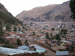
Huancavelica District
Huancavelica
Wankawillka | |
|---|---|
 Huancavelica | |
| Country | |
| Region | Huancavelica |
| Province | Huancavelica |
| Capital | Huancavelica |
| Government | |
| • Mayor | Rómulo Cayllahua Paytán (2019–2022) |
| Area | |
| • Total | 514.1 km2 (198.5 sq mi) |
| Elevation | 3,660 m (12,010 ft) |
| Population (2017) | |
| • Total | 39,776 |
| • Density | 77/km2 (200/sq mi) |
| Time zone | UTC-5 (PET) |
| UBIGEO | 090101 |
Huancavelica District is one of nineteen districts of the province Huancavelica in Peru.[1]
Geography[edit]
The Chunta mountain range traverses the district. Some of the highest mountains of the district are listed below:[2]
- Hatun Pirwayuq
- Hatun Q'asa
- Huch'uy Pirwayuq
- Kachi Mach'ay Urqu
- Kuntur Wamani
- Pinqullu
- Puka Q'asa
- Puka Urqu
- Puywan
- Qarwa K'anti
- Qarwa Urqu
- Qarwarasu
- Qucha Q'asa
- Tiklla Q'asa
- Ukhu P'ukru
- Wachu Intiyuq
- Wamanrasu
- Waqutuyuq
- Wayq'u Kancha
- Yana Kancha
See also[edit]
References[edit]
- ^ (in Spanish) Instituto Nacional de Estadística e Informática. Banco de Información Distrital Archived 2008-04-23 at the Wayback Machine. Retrieved April 11, 2008.
- ^ escale.minedu.gob.pe/ UGEL map Huancavelica Province 1 (Huancavelica Region)


