
Mariyala
Mariyala | |
|---|---|
 Mariyala School | |
| Coordinates: 11°56′49″N 76°54′29″E / 11.946930°N 76.908124°E | |
| Country | |
| State | Karnataka |
| District | Chamarajanagar |
| Time zone | UTC+05:30 (IST) |
| Vehicle registration | KA |
Mariyala is a village in Chamarajanagar district of Karnataka state, India.
Location[edit]
Mariyala is located at 4.8 kilometer northwest of Chamarajanagar town.[1]

Transportation[edit]
Mariyala is served by Mariyala Gangavadi railway station. The village is on the highway between Chamarajanagar and Mysore.
Post Offices[edit]
Demographics[edit]
2,255 people live in the village in 591 families. The literacy rate is 55%. The village is ruled by a sarpanch.
Education[edit]
- Government Primary School, Mariyala is at the very beginning of the village directly opposite to the village temple.
- There is a new private P.U.College at the end of the village.
- JSS Institute, Mariyala gives training to become electricians, fitters, electronics mechanics etc. The trainees are assisted for placements through SJCE Mysore.[4]
See also[edit]
Image Gallery[edit]
-
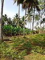 Banana Farm
 -
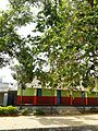 Alahundi School
 -
 The village gate
 -
 Village temple
 -
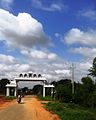
 Village Arch
 -
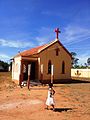 Kellamballi Church
 -
 Kantheeshwara Restaurant


References[edit]
- ^ "Chamarajanagar to Mariyala". Chamarajanagar to Mariyala. Retrieved 5 May 2021.
- ^ "Mariyala Pin Code | Mariyala Postal Index Number Code (Pincode)". www.mapsofindia.com. Retrieved 5 May 2021.
- ^ "Gangavadi Pin Code - Chamrajnagar, Karnataka, India". PINcodeNo.com. Archived from the original on 21 August 2016. Retrieved 2 October 2021.
- ^ "JSS Industrial Traning [sic] Centre, Chamarajanagar". JSS Mahavidyapeetha. Archived from the original on 3 February 2020. Retrieved 2 October 2021.