
Tulip Cemetery
Tulip Cemetery | |
 Tulip Cemetery, showing the full extent. Graves begin near the road in front of the pavilion on the left edge of the photograph, and continue all the way to the right edge of the image. | |
 Location in Arkansas  Location in United States | |
| Location | Off AR 9, Tulip, Arkansas |
|---|---|
| Coordinates | 34°4′40″N 92°39′28″W / 34.07778°N 92.65778°W |
| Area | 2.7 acres (1.1 ha) |
| Built | 1842 |
| MPS | Dallas County MRA |
| NRHP reference No. | 83003543[1] |
| Added to NRHP | October 28, 1983 |
Tulip Cemetery is a historic cemetery in Tulip, a small hamlet in rural Dallas County, Arkansas. It is located off Arkansas Highway 9, just behind the Tulip Methodist Church, occupying a high spot in the area. Tulip was one of the first settlements in Dallas County; the cemetery's oldest documented grave dates to 1847. It also includes the graves of six Confederate Army soldiers.[2]
The cemetery was listed on the National Register of Historic Places in 1983.[1]
-
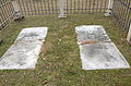 Headstones at cemetery
 -
 Tulip Cemetery Church
 -
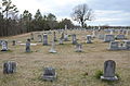 Field of headstones
 -
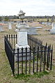
 Headstone from 1857
 -
 Headstone
 -
 Main gates


See also[edit]
References[edit]
- ^ a b "National Register Information System". National Register of Historic Places. National Park Service. July 9, 2010.
- ^ "NRHP nomination for Tulip Cemetery". Arkansas Preservation. Retrieved 2014-07-16.
| Topics | |
|---|---|
| Lists by state |
|
| Lists by insular areas | |
| Lists by associated state | |
| Other areas | |
| Related | |