
Valle Crucis Historic District
Valle Crucis Historic District | |
 Valle Crucis Methodist Church, 2017 | |
  | |
| Location | Along NC 194 and NC 1112, Valle Crucis, North Carolina |
|---|---|
| Coordinates | 36°12′33″N 81°46′43″W / 36.20917°N 81.77861°W |
| Area | 909 acres (368 ha) |
| Architectural style | Gothic Revival, Bungalow/Craftsman, Colonial Revival |
| NRHP reference No. | 04001600[1] |
| Added to NRHP | February 2, 2005 |
Valle Crucis Historic District is a national historic district located at Valle Crucis, Watauga County, North Carolina. The district encompasses 50 contributing buildings, 1 contributing site, and 7 contributing structures in the central business district and surrounding residential sections of Valle Crucis. It developed between about 1812 and 1954, and includes notable examples of Gothic Revival, Bungalow / American Craftsman, and Colonial Revival style architecture. Located in the district are the separately listed Mast General Store, Mast Farm, and Valle Crucis Episcopal Mission. Other notable contributing buildings are the Baird Farm (c. 1860, c. 1872), Lucy Mast Olsen House (1936-1940), Taylor tobacco barn, Farthing Store (1909), Valle Crucis Bank (1914), Hard Taylor House (c. 1855, 1895), and C. D. "Squire" Taylor House (1911).[2]
It was listed on the National Register of Historic Places in 2005.[1]
Gallery[edit]
-
 Mast General Store, 2017
 -
 (former) Valle Crucis Academy, 2017
 -
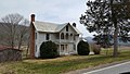 David F. Baird House, 2017
 -
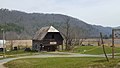 David F. Baird Barn, 2017
 -
 Farthing Store, 2017
 -
 Hard Taylor House, 2017
 -
 W.H. & Mollie Mast House (Willow House), 2017
 -
 W.W. Mast House, 2017

_Valle_Crucis_Academy.jpg)


.jpg)

References[edit]
- ^ a b "National Register Information System". National Register of Historic Places. National Park Service. July 9, 2010.
- ^ Cynthia de Miranda; Clay Griffith & Jennifer Martin (February 2003). "Valle Crucis Historic District" (pdf). National Register of Historic Places - Nomination and Inventory. North Carolina State Historic Preservation Office. Retrieved July 1, 2015.

- Historic districts on the National Register of Historic Places in North Carolina
- Gothic Revival architecture in North Carolina
- Colonial Revival architecture in North Carolina
- Buildings and structures in Watauga County, North Carolina
- National Register of Historic Places in Watauga County, North Carolina
- Western North Carolina Registered Historic Place stubs