Belén de Umbría
Belén de Umbría | |
|---|---|
Municipality and town | |
 Bethlehem Umbria Church | |
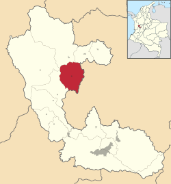
 Location of the municipality and town of Belén de Umbría in the Risaralda Department of Colombia. | |
| Country | |
| Department | Risaralda Department |
| Elevation | 1,634 m (5,361 ft) |
| Population (2023) | |
| • Total | 25,276 |
| Time zone | UTC-5 (Colombia Standard Time) |
Belén de Umbría is a town and municipality in the Department of Risaralda, Colombia. At a distance of approximately 70 kilometers from the capital Pereira.[1] In 2023 the town had an estimated population of 25,276.[2]
History[edit]
The name Belén was chosen by a bishop who visited these lands in 1902, because they say that when he arrived at the village he commented: "this place looks like a manger, it should be called Bethlehem" and Umbria in homage to the Umbra, one of the most prominent tribes of this region. It was founded on August 10, 1890 and at this time it has more than 25,000 inhabitants.[3]
Climate[edit]
Belén de Umbría is stuated 1,634 metres above sea level, due to that elevation the town has a subtropical highland climate with an average annual temperature of 20°C.[1]
References[edit]
- ^ a b Risaralda, Gobernación de (2016-09-28). "Belén de Umbría". Gobernación de Risaralda (in Spanish). Retrieved 2023-09-27.
- ^ Telefónicas, Telencuestas-Encuestas. "Cuántos habitantes tiene Belén de Umbría, Risaralda en 2023". Telencuestas (in Spanish). Retrieved 2023-09-27.
- ^ admin (2015-11-01). "Belen de Umbría, 125 Años de historia alrededor de la caficultura". Destino Café (in Spanish). Retrieved 2023-09-27.


