
Stanton Mountain
| Stanton Mountain | |
|---|---|
.jpg) Stanton Mountain with Mount Vaught behind it | |
| Highest point | |
| Elevation | 7,750 ft (2,360 m)[1] |
| Prominence | 630 ft (190 m)[1] |
| Parent peak | Mount Vaught (8,854 ft)[2] |
| Isolation | 1.66 mi (2.67 km)[2] |
| Coordinates | 48°39′36″N 113°53′39″W / 48.659901°N 113.894203°W[1] |
| Naming | |
| Etymology | Lottie Stanton |
| Geography | |
 Stanton Mountain Location in Montana  Stanton Mountain Location in the United States | |
| Location | Flathead County, Montana, U.S. |
| Parent range | Livingston Range |
| Topo map | USGS Camas Ridge East |
| Climbing | |
| Easiest route | class 4 scrambling[2] |
Stanton Mountain is a 7,750 feet (2,360 m) mountain summit located in the Livingston Range, of Glacier National Park in the U.S. state of Montana.[3] Stanton Mountain rises more than 4,500 feet (1,400 m) above the northern shore of Lake McDonald. The mountain's name refers to Mrs. Lottie Stanton who lived near the west side of the park in the late 1800s, and with her husband operated a livery stable in historic Demersville.[4] She was a pioneering woman who followed the construction camps during the railroad building days.[5] The mountain's name was officially adopted in 1929.[3] In the late 1800s it was known as Mt. Lottie Stanton.[6] The nearest higher peak is Mount Vaught, 1.38 miles (2.22 km) to the northeast.[1] Precipitation runoff from the mountain drains into tributaries of the Flathead River.
Climate[edit]
Based on the Köppen climate classification, Stanton Mountain is located in a subarctic climate zone characterized by long, usually very cold winters, and short, cool to mild summers.[7] Temperatures can drop below −10 °F with wind chill factors below −30 °F.
Geology[edit]
Like other mountains in Glacier National Park, Stanton Mountain is composed of sedimentary rock laid down during the Precambrian to Jurassic periods. Formed in shallow seas, this sedimentary rock was initially uplifted beginning 170 million years ago when the Lewis Overthrust fault pushed an enormous slab of precambrian rocks 3 mi (4.8 km) thick, 50 miles (80 km) wide and 160 miles (260 km) long over younger rock of the cretaceous period.[8]
See also[edit]
- List of mountains and mountain ranges of Glacier National Park (U.S.)
- Geology of the Rocky Mountains
Gallery[edit]
-
 Mallards flying towards Stanton
 -
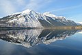 Stanton Mountain (left) reflected in Lake McDonald
 -
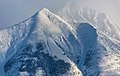
 Stanton Mountain
 -
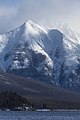 Stanton Mountain in winter
 -
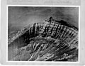 Aerial view of east aspect, circa 1925
 -


.jpg)
References[edit]
- ^ a b c d "Mount Stanton, Montana". Peakbagger.com. Retrieved 2019-01-27.
- ^ a b c "Stanton Mountain - 7,750' MT". listsofjohn.com. Retrieved 2021-10-09.
- ^ a b "Stanton Mountain". Geographic Names Information System. United States Geological Survey, United States Department of the Interior. Retrieved 2019-01-27.
- ^ Place Names of Glacier National Park, Jack Holterman, Riverbend Publishing, 2006, ISBN 1931832684.
- ^ Through The Years In Glacier National Park An Administrative History, NPS.gov
- ^ L. W. Chaney, A Glacier in the Montana Rockies, December 13, 1895, page 793.
- ^ Peel, M. C.; Finlayson, B. L.; McMahon, T. A. (2007). "Updated world map of the Köppen−Geiger climate classification". Hydrol. Earth Syst. Sci. 11 (5): 1633–1644. Bibcode:2007HESS...11.1633P. doi:10.5194/hess-11-1633-2007. ISSN 1027-5606. S2CID 9654551.
- ^ Gadd, Ben (2008). "Geology of the Rocky Mountains and Columbias".
{{cite journal}}: Cite journal requires|journal=(help)
External links[edit]
- National Park Service web site: Glacier National Park
- Lake McDonald web cam with Stanton on the left: National Park Service
- Stanton Mountain weather: Mountain Forecast