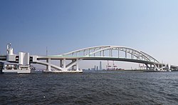
Yumemai Bridge
Yumemai Bridge 夢舞大橋 | |
|---|---|
 Yumemai Bridge, Osaka | |
| Coordinates | 34°39′31.8″N 135°23′58.5″E / 34.658833°N 135.399583°E |
| Carries | Motor vehicles |
| Crosses | Port of Osaka |
| Locale | Konohana, Osaka, Japan |
| Named for | Yumeshima and Maishima (islands) |
| Characteristics | |
| Total length | 876m[1] |
| Width | 33.8m |
| Longest span | 280m |
| History | |
| Constructed by | IHI, MHI, KHI |
| Construction start | 1999 |
| Construction end | 2001 |
| Construction cost | ¥63,500,000,000 (~$530,000,000) |
| Opened | 1 August 2009[2] |
| Location | |
 | |
The Yumemai Bridge (夢舞大橋, yumemai ōhashi) is a floating moveable bridge in Konohana District, Osaka, Japan. It spans the North Waterway connecting the man-made islands Yumeshima and Maishima of Osaka Port.[3]
It comprises a floating bridge over the waterway, transitional girder bridges on both ends of the floating bridge, and approach bridges on Yumeshima and Maishima. The bridge is supported on two large steel pontoons. Ordinarily, the bridge allows a navigation passage width of 135m. In the event that the main waterway is out of service, the bridge is swung by tugboats to widen the passage width to 200m or more, enabling the passage of larger vessels.[4]
See also[edit]
References[edit]
- ^ "橋梁年鑑 夢舞大橋 詳細データ". Retrieved 24 December 2013.
- ^ "夢舞大橋". ニッポン旅マガジン. Retrieved 19 September 2022.
- ^ Watanabe, E.; Maruyama, T.; Ueda, S.; Tanaka, H. (2015). "Yumemai Floating Swing Arch Bridge of Osaka, Japan". Large Floating Structures. Ocean Engineering & Oceanography. Vol. 3. pp. 61–90. doi:10.1007/978-981-287-137-4_3. ISBN 978-981-287-136-7.
- ^ "Data" (PDF). bridgeworld.net. Retrieved 20 July 2021.
