
Cuervo, New Mexico
Cuervo, New Mexico | |
|---|---|
.jpg) Church and its deteriorated rectory in Cuervo | |
 Cuervo  Cuervo | |
| Coordinates: 35°01′52″N 104°24′31″W / 35.03111°N 104.40861°W | |
| Country | United States |
| State | New Mexico |
| County | Guadalupe |
| Elevation | 4,859 ft (1,481 m) |
| Time zone | UTC-7 (Mountain (MST)) |
| • Summer (DST) | UTC-6 (MDT) |
| ZIP code | 88417 |
| Area code | 575 |
| GNIS feature ID | 915818[1] |
Cuervo is an unincorporated community in Guadalupe County, New Mexico, United States.[1] Cuervo is located along Interstate 40 16.8 miles (27.0 km) east-northeast of Santa Rosa. Cuervo had a post office until September 10, 2011; it still has its own ZIP code, 88417.[2][3] The community is nearly a ghost town now, having been split by the construction of I-40; but there is still a small church and a gas station.[4]
Cuervo was founded in 1901, and a post office was opened there in 1902, although records indicate that there was a settlement there prior to 1901. It began as a supply center for ranches in the area; by 1926, it had become a stop on Route 66 for travellers. The 1940 census recorded a population of 128, although by that time there were "few gas stations, groceries, no café, garage or other tourist accommodations." By 2011 the shell of an old stone schoolhouse and a stone church were still standing[5]
Cuervo consists of four streets south of I-40 and two streets north of the interstate. Nearly all of the structures in the community are abandoned and very deteriorated. The town began in 1901 when the railroad came through. The town started to grow when the surrounding land was opened to cattle ranching in 1910. Then Route 66 came, and the town's population peaked in the 1940s at over 300. There are two homes in the community that appear updated and inhabited, along with one auto repair business. The community's long-abandoned school building and church appear to be undergoing restoration.
Gallery[edit]
-
 crumbling adobe building
 -
 old stone schoolhouse with abandoned vehicle
 -
 woodframe structure
 -
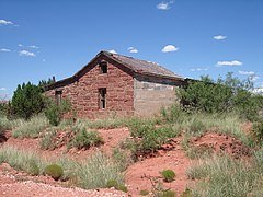 old stone schoolhouse
 -
 water tower
.jpg)
.jpg)
.jpg)
.jpg)
.jpg)
References[edit]
- ^ a b "Cuervo". Geographic Names Information System. United States Geological Survey, United States Department of the Interior.
- ^ United States Postal Service (2012). "USPS - Look Up a ZIP Code". Retrieved February 15, 2012.
- ^ "Postmaster Finder - Post Offices by ZIP Code". United States Postal Service. Archived from the original on October 17, 2020. Retrieved August 11, 2013.
- ^ "Where the Crows Flew: Cuervo, New Mexico". June 30, 2013.
- ^ Hinkley, Jim (2011). Ghost Towns of Route 66. Minneapolis: Voyageur Press. p. 100. ISBN 978-0-7603-3843-8.
Municipalities and communities of Guadalupe County, New Mexico, United States | ||
|---|---|---|
| City |  | |
| Town | ||
| CDPs | ||
| Other unincorporated community | ||
External links[edit]
History and photos *[1]
This New Mexico state location article is a stub. You can help Wikipedia by expanding it. |