Popowice, Łódź Voivodeship
Popowice | |
|---|---|
Village | |
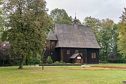
 All Saints church in Popowice | |
| Coordinates: 51°9′N 18°34′E / 51.150°N 18.567°E | |
| Country | |
| Voivodeship | Łódź |
| County | Wieluń |
| Gmina | Pątnów |
| Population | 500 |
| Time zone | UTC+1 (CET) |
| • Summer (DST) | UTC+2 (CEST) |
| Vehicle registration | EWI |
Popowice [pɔpɔˈvit͡sɛ] is a village in the administrative district of Gmina Pątnów, within Wieluń County, Łódź Voivodeship, in south-central Poland. It lies approximately 4 kilometres (2 mi) west of Pątnów, 9 km (6 mi) south of Wieluń, and 94 km (58 mi) south-west of the regional capital Łódź.[1]
History[edit]
The territory became a part of the emerging Polish state in the 10th century. The All Saints church was built in the early 16th century, and was part of the Catholic parish in nearby Kadłub.[2]
During the German occupation of Poland (World War II), in 1940, the German gendarmerie carried out expulsions of Poles, who were placed in a transit camp in Łódź, and then young Poles were deported to forced labour in Germany and German-occupied France, and others were deported to the General Government in the more eastern part of German-occupied Poland.[3] Houses and farms of expelled Poles were handed over to German colonists as part of the Lebensraum policy.[4]
References[edit]
- ^ "Central Statistical Office (GUS) – TERYT (National Register of Territorial Land Apportionment Journal)" (in Polish). 2008-06-01.
- ^ Słownik geograficzny Królestwa Polskiego i innych krajów słowiańskich, Tom VIII (in Polish). Warsaw. 1887. p. 799.
{{cite book}}: CS1 maint: location missing publisher (link) - ^ Wardzyńska, Maria (2017). Wysiedlenia ludności polskiej z okupowanych ziem polskich włączonych do III Rzeszy w latach 1939-1945 (in Polish). Warsaw: IPN. p. 253. ISBN 978-83-8098-174-4.
- ^ Wardzyńska, p. 255

