
Arunkhola
Arunkhola
आरूङ्गखोला | |
|---|---|
 Arunkhola | |
| Nicknames: Aarungkhola, Aarunkhola, Bhagra | |
| Country | Nepal |
| Time zone | UTC+5:45 |
| A.P.O. (Postal code) | 33006 |
| Area code | 078 |
Arunkhola (Nepali: अरुणखोला) is a town situated on the bank of the river Arun (formerly Arung, named after its source in Palpa) before as Naya Belhani VDC Ward No. 8 of Nawalparasi, but now as Madhyabindu Municipality, ward no. 10, Nawalpur District of Western Nepal. It is also known as Aarungkhola (Nepali: आरुङ्गखोला), Aarunkhola(Nepali: आरुणखोला) and Bhagra (Nepali: भाग्रा) (old-fashioned name). It is an emerging business hub of the district.[1]
The east-to-west Mahendra Highway passes through the Arunkhola bazaar, and is 197 km southwest of the capital city Kathmandu. Even though it covers about 100 km2 of the Naya Belhani VDC, it is densely populated.
Commerce[edit]
Arunkhola lies between Butwal (63 km) and Narayan Ghat (52 km), two major cities of Nepal. It is a major market for Eastern Palpa. Arunkhola is not that far from India either, a 3 hours walk to Triveni, a border town. It has a potential of becoming a major business hub in the area.
While a large number of people in Arunkhola rely on business, its economy is still mainly based on agriculture, service and trade. There are big markets all around Arunkhola. There is also a big community of ex-servicemen of the British and Indian Army, an ex-service men colony in the south of Arunkhola. Arunkhola is about 3 km north of Narayani river and Charkoshe Jhhadi - the largest forest of Nepal and the home of wild animals such as Rhinos, Tigers, etc. There are five 'A' level banks and some small co-operatives in operation. The villages around Arunkhola are Bhiuran, Kusunde, Tamaspur, Belhani, Khayarsal, Karamghari and Charikun. Arunkhola being a relatively new town, it is possible to see people from almost all parts of Nepal in Arunkhola.
Population[edit]
According to the 2011 Census, 4,265 people live in 1,028 households. This includes 1,926 males and 2,339 females.[2]
Schools[edit]
- Shree Janata Higher Secondary School (public)
- Shree Janata Secondary School (public)
- Shree Aarungkhola Secondary Boarding School (private)
- Shree Narayani Boarding School (private)
- Shree Shantideep Boarding School( private)
- Little Step Academy (private)
- Nepal Open University
- HEALTH
- Manu Hospital
- Mini Princeton Hospital
- Nepal Public Hospital
- City Hospital
- Arunkhola Medical College
- WHO INTL. Medical College
- Bishow Pharmecy
Gallery[edit]
-
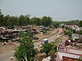
 Arunkhola view from the top of the Indira Hotel (east side view)
 -
 Arunkhola view from the top of Indira Hotel (west side view)


References[edit]
- ^ "Brief Introdution [sic] of Arun Khola". Archived from the original on 2012-03-18. Retrieved 2011-07-30.
- ^ "District-wise Population of Nepal CBS 2011". umeshg.com.np.
27°37′N 83°57′E / 27.617°N 83.950°E
This article about a location in the Nawalpur District of Nepal is a stub. You can help Wikipedia by expanding it. |