
Wadi Tuwa
Wadi Tuwa | |
|---|---|
 Wadi Tuwa | |
| Coordinates: 25°01′15″N 56°07′32.5″E / 25.02083°N 56.125694°E | |
| Country | United Arab Emirates |
| Emirate | Ras Al Khaimah |
| Elevation | 401 m (1,318 ft) |
Wadi Tuwa is a wadi, a seasonal waterway, in the Hajar Mountains of Ras Al Khaimah, United Arab Emirates. The wadi is dammed by the Wadi Tuwa Dam.
A popular spot with campers and hikers,[1] Wadi Tuwa is a fertile wadi with many traditional farms dotted throughout its course. Crops cultivated in the wadi include mangoes, dates, onions and tobacco,[2] watered by a number of wells throughout its southeasterly course.[3]
There are a number of petroglyphs, or rock carvings, to be found throughout the wadi, including distinctive leopards, camels, mounted men and horses. These are of a type found in the region, in the Wadi Ejili, Wadi Khadra and Wadi Shawka in particular.[4]
-
 The dam across Wadi Tuwa
 -
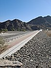
 Wadi Tuwa looking up-wadi from the dam


See also[edit]
References[edit]
- ^ Publishing, Explorer. "Wadi Tuwa & Ejeli". www.askexplorer.com. Retrieved 2020-10-25.
- ^ "Desert survival". The National. 28 June 2011. Retrieved 2020-10-25.
- ^ Lancaster, William, 1938- (2011). Honour is in contentment : life before oil in Ras al-Khaimah (UAE) and some neighbouring regions. Lancaster, Fidelity. Berlin: De Gruyter. p. 201. ISBN 978-3-11-022340-8. OCLC 763160662.
{{cite book}}: CS1 maint: multiple names: authors list (link) CS1 maint: numeric names: authors list (link) - ^ Lancaster, William; Lancaster, Fidelity (2011). "A discussion of rock carvings in Ra's al Khaimah Emirate, UAE, and Musandam province, Sultanate of Oman, using local considerations". Arabian Archaeology and Epigraphy. 22 (2): 166–195. doi:10.1111/j.1600-0471.2011.00338.x. ISSN 1600-0471.