
Kellyton, Alabama
Kellyton, Alabama | |
|---|---|
Town | |
 Kellyton, Alabama in 2011 | |
 Location of Kellyton in Coosa County, Alabama. | |
 Kellyton | |
| Coordinates: 32°58′47″N 86°02′01″W / 32.97972°N 86.03361°W | |
| Country | United States |
| State | Alabama |
| County | Coosa |
| Area | |
| • Total | 0.97 sq mi (2.51 km2) |
| • Land | 0.97 sq mi (2.50 km2) |
| • Water | 0.00 sq mi (0.00 km2) |
| Elevation | 761 ft (232 m) |
| Population (2020) | |
| • Total | 129 |
| • Density | 133.40/sq mi (51.52/km2) |
| Time zone | UTC-6 (Central (CST)) |
| • Summer (DST) | UTC-5 (CDT) |
| Area code(s) | 256 & 938 |
| FIPS code | 01-39472 |
| GNIS feature ID | 121129[2] |
Kellyton is an incorporated town[3] in Coosa County, Alabama, United States. It had a population of 217 as of the 2010 census.[4]
The town is part of the Talladega-Sylacauga Micropolitan Statistical Area.
Demographics[edit]
| Census | Pop. | Note | %± |
|---|---|---|---|
| 1920 | 241 | — | |
| 1930 | 168 | −30.3% | |
| 2010 | 217 | — | |
| 2020 | 129 | −40.6% | |
| U.S. Decennial Census[5] 2013 Estimate[6] | |||
Kellyton was previously listed in the 1920 and 1930 U.S. Censuses as an incorporated community. It did not appear again on the census until 2010.
Notable person[edit]
- Justin Tuck, NFL player
Gallery[edit]
-
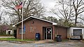 Kellyton Post Office (ZIP code: 35089)
 -
 Jackson's Gap Volunteer Fire Department


References[edit]
- ^ "2020 U.S. Gazetteer Files". United States Census Bureau. Retrieved October 29, 2021.
- ^ "Kellyton". Geographic Names Information System. United States Geological Survey, United States Department of the Interior.
- ^ "Boundary Changes". Geographic Change Notes: Alabama. Population Division, United States Census Bureau. May 19, 2006. Archived from the original on February 6, 2006. Retrieved August 24, 2008.
- ^ "Geographic Identifiers: 2010 Demographic Profile Data (G001): Kellyton town, Alabama". U.S. Census Bureau, American Factfinder. Archived from the original on February 12, 2020. Retrieved June 9, 2014.
- ^ "U.S. Decennial Census". Census.gov. Retrieved June 6, 2013.
- ^ "Annual Estimates of the Resident Population: April 1, 2010 to July 1, 2013". Archived from the original on May 22, 2014. Retrieved June 3, 2014.
Municipalities and communities of Coosa County, Alabama, United States | ||
|---|---|---|
| Towns | 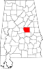 | |
| CDPs | ||
| Other unincorporated communities | ||
| Footnotes | ‡This populated place also has portions in an adjacent county or counties | |