Valdorf
Valdorf | |
|---|---|
Village | |
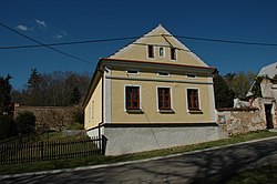
 A house in Horní Valdorf | |
| Coordinates: 49°30′15″N 12°56′3″E / 49.50417°N 12.93417°E | |
| Country | |
| Region | Plzeň |
| District | Domažlice |
| Municipality | Horšovský Týn |
| First mentioned | 1789 |
| Area | |
| • Total | 3.64 km2 (1.41 sq mi) |
| Elevation | 425 m (1,394 ft) |
| Population (2021)[1] | |
| • Total | 23 |
| • Density | 6.3/km2 (16/sq mi) |
| Time zone | UTC+1 (CET) |
| • Summer (DST) | UTC+2 (CEST) |
| Postal code | 346 01 |
Valdorf is a village and administrative part of Horšovský Týn in Domažlice District, the Czech Republic. It has about 20 inhabitants. It is formed by two urbanistically separated parts: Dolní Valdorf and Horní Valdorf.
History[edit]
The first written mention of Valdorf is from 1789.[2] Between 1869 and 1960 it was a hamlet of Horšovský Týn and in 1961 it become part of that town.[3] In 1870 its inhabitants were predominantly German.[4]
Description[edit]

The village of Valdorf is located south of Horšovský Týn near the Podháj hill. The road connecting Němčice and Horšovský Týn divides it into two parts: Dolní (Lower, in the west) and Horní (Upper, in the east) Valdorf.
Dolní Valdorf is located at the foot of the Podháj hill on the Podhájský stream. It consists of several cottages that stand by the pond. In the middle of the village, there is a crossroads, the neogothic[5] chapel of the Holy Family, and the wayside shrine. A green tourist route connecting Horšovský Týn and Domažlice passes through Dolní Valdorf from north to south.

Horní Waldorf is located on the opposite side of the hill. A path passes through its center and climbs up to elevation 447, where the cross is located. Most of the buildings are scattered along this road. Below this part, there are three ponds in the valley on the stream.
Between the individual built-up parts, there are fields and meadows, and at the crossing of the roads there is a cross, there is a factory of spreading materials.
References[edit]
- ^ "Výsledky sčítání 2021 – otevřená data" (in Czech). Czech Statistical Office. 2022-12-21.
- ^ "Historický lexikon obcí České republiky 1869–2005 (1. díl)" (in Czech). Czech Statistical Office. 2004-12-31. Retrieved 2023-02-19.
- ^ Historický lexikon obcí České republiky 1869-2005. Jiřina Růžková, Josef Škrabal, Český statistický úřad. Praha: Český statistický úřad. 2006. p. 553. ISBN 80-250-1277-8. OCLC 85844975.
{{cite book}}: CS1 maint: others (link) - ^ Orth, Ev. (1870). Podrobný popis všech měst, městysů, vesnic, pak zámků, dvorů, továren, mlýnů, hutí a podobných o samotě ležících stavení, jakož i všech zpustlých hradů a zaniklých osad Království Českého (in Czech). Prague: I. L. Kober. p. 882.
- ^ Český les : příroda, historie, život. Jan Andreska, Vladislav Dudák (1 ed.). Praha: Baset. 2005. p. 543. ISBN 80-7340-065-0. OCLC 65520326.
{{cite book}}: CS1 maint: others (link)
External links[edit]
 Media related to Valdorf (Horšovský Týn) at Wikimedia Commons

