
Tonsa
| Tonsa | |
|---|---|
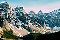
 Tonsa (center) seen from Larch Valley flanked by Mount Bowlen on left and Mount Perren on right | |
| Highest point | |
| Elevation | 3,053 m (10,016 ft)[1] |
| Prominence | 173 m (568 ft)[1] |
| Parent peak | Mount Bowlen (3,072 m)[1] |
| Listing | |
| Coordinates | 51°17′51″N 116°12′00″W / 51.29750°N 116.20000°W[1] |
| Geography | |
 Tonsa Location on Alberta and British Columbia border  Tonsa Tonsa (British Columbia) | |
| Country | Canada |
| Provinces | Alberta and British Columbia |
| Protected area | Banff National Park |
| Parent range | Bow Range Canadian Rockies[1] |
| Topo map | NTS 82N8 Lake Louise |
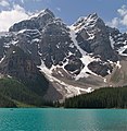
Tonsa, or Tonsa Peak, is a 3,053-metre (10,016 ft) mountain summit located on the border of Alberta and British Columbia on the Continental Divide in the Canadian Rockies. The mountain forms part of the backdrop to Moraine Lake in the Valley of the Ten Peaks of Banff National Park. It was named in 1894 by Samuel E.S. Allen for the Stoney Indian word for the number four. [2]
Geology[edit]
Like other mountains in Banff Park, Tonsa is composed of sedimentary rock laid down during the Precambrian to Jurassic periods.[3] Formed in shallow seas, this sedimentary rock was pushed east and over the top of younger rock during the Laramide orogeny.[4]
Climate[edit]
Based on the Köppen climate classification, Tonsa is located in a subarctic climate zone with cold, snowy winters, and mild summers.[5] Winter temperatures can drop below −20 °C with wind chill factors below −30 °C. Precipitation runoff from Tonsa drains east into tributaries of the Bow River, or west into tributaries of the Vermilion River.
See also[edit]
- List of peaks on the British Columbia–Alberta border
- Geography of Alberta
- Geography of British Columbia
References[edit]
- ^ a b c d e "Tonsa Peak". Bivouac.com. Retrieved 2018-12-12.
- ^ "Tonsa". cdnrockiesdatabases.ca. Retrieved 2019-09-24.
- ^ Belyea, Helen R. (1960). The Story of the Mountains in Banff National Park (PDF). parkscanadahistory.com (Report). Ottawa: Geological Survey of Canada. Archived (PDF) from the original on 2015-10-02. Retrieved 2019-09-13.
- ^ Gadd, Ben (2008). Geology of the Rocky Mountains and Columbias.
- ^ Peel, M. C.; Finlayson, B. L.; McMahon, T. A. (2007). "Updated world map of the Köppen−Geiger climate classification". Hydrol. Earth Syst. Sci. 11: 1633–1644. ISSN 1027-5606.
Gallery[edit]
-
 Road to Moraine Lake, yellow centerline aimed at Tonsa
 -
 Tonsa to left of center
 -

-
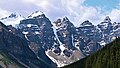
 Moraine Lake peaks
 -
 Mt. Bowlen and Tonsa
 -
 Mt. Bowlen (left) and Tonsa (right)
 -
 Tonsa centered

.jpg)


.jpg)


External links[edit]
- Parks Canada web site: Banff National Park
- Parks Canada web site: Kootenay National Park
- Tonsa weather: Mountain Forecast