
E. G. Sewell Park
| Sewell Park | |
|---|---|
 Sewell Park Sign | |
 | |
| Type | Municipal |
| Location | 1801 NW S River Drive Miami, FL 33125 |
| Coordinates | 25°47′06″N 80°13′27″W / 25.78500°N 80.22417°W |
| Area | 10.33 acres (0.0418 km2) |
| Created | |
| Operated by | Miami-Dade Parks and Recreation Department |
| Open | 9 a.m.–5 p.m. |
| Website | miamigov |
E. G. Sewell Park is a 10.33-acre (4.18 ha) riverfront park located close to the 17th Street Bridge over the Miami River, in Miami, Florida, United States.[1] The site marks the tropical garden area of property purchased in 1897 by General Samuel Crocker Lawrence.
Lawrence created a lushly landscaped garden of royal palms with a guest house and a boat slip, and grew grapefruit on much of the remainder of his land. The royal palms remain, as do the boat slip, the steps, columns, and foundation of the guest house, and a water pump Lawrence used to irrigate the tropical plants and the grapefruit groves nearby.
The park is named for former Miami mayor E. G. Sewell.[2][3]
Gallery[edit]
-
 Concrete and stone stair ruins
 -
 General view
 -
 Miami River and grassy knoll
 -
 Old machinery
 -
 Boat Ramp and 17th Street bridge
 -

-
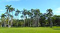 Royal palm grove


References[edit]
- ^ "2014 Park List" (PDF). Miamigov.com. Retrieved 2018-06-28.
- ^ "E. G. Sewell Park". Miamigov.com. Archived from the original on 2012-07-16. Retrieved 2018-06-26.
- ^ "Miami River Commission". www.wpbt2.org. Retrieved 2018-06-28.