
Płonina, Lower Silesian Voivodeship
Płonina | |
|---|---|
Village | |
 View of the village | |
 Płonina Location of Płonina, Lower Silesian Voivodeship | |
| Coordinates: 50°55′00″N 16°00′00″E / 50.91667°N 16.00000°E | |
| Country | |
| Voivodeship | Lower Silesian |
| Powiat | Jawor |
| Gmina | Bolków |
| Population | 157 |
Płonina [pwɔˈnina] is a village in the administrative district of Gmina Bolków, within Jawor County, Lower Silesian Voivodeship, in south-western Poland.
It lies approximately 8 km (5 mi) west of Bolków, 20 km (12 mi) south-west of Jawor, and 77 km (48 mi) west of the regional capital Wrocław.
Buildings of interest[edit]
Niesytno Castle lies on a small hill near Płonina.
Gallery[edit]
-
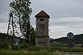 Electric station
 -
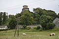 Castle and cows
 -
 Houses by road
_(005).jpg)
_(007).jpg)
_(010).jpg)
References[edit]
Wikimedia Commons has media related to Płonina, Lower Silesian Voivodeship.
| Town and seat |  | |
|---|---|---|
| Villages | ||
This Jawor County location article is a stub. You can help Wikipedia by expanding it. |