
Wasigny–Mézières railway
| Wasigny–Mézières | ||||||||||||||||||||||||||||||||||||||||||||||||||||||||||||||||||||||||||||||||||||||||||||||||||||||||||||||||||||||||||||||||||||||||||||||||||||||||
|---|---|---|---|---|---|---|---|---|---|---|---|---|---|---|---|---|---|---|---|---|---|---|---|---|---|---|---|---|---|---|---|---|---|---|---|---|---|---|---|---|---|---|---|---|---|---|---|---|---|---|---|---|---|---|---|---|---|---|---|---|---|---|---|---|---|---|---|---|---|---|---|---|---|---|---|---|---|---|---|---|---|---|---|---|---|---|---|---|---|---|---|---|---|---|---|---|---|---|---|---|---|---|---|---|---|---|---|---|---|---|---|---|---|---|---|---|---|---|---|---|---|---|---|---|---|---|---|---|---|---|---|---|---|---|---|---|---|---|---|---|---|---|---|---|---|---|---|---|---|---|---|---|
_gare_de_Wasigny-La_Neuville_(2).JPG) Wasigny-La Neuville station
| ||||||||||||||||||||||||||||||||||||||||||||||||||||||||||||||||||||||||||||||||||||||||||||||||||||||||||||||||||||||||||||||||||||||||||||||||||||||||
| Technical | ||||||||||||||||||||||||||||||||||||||||||||||||||||||||||||||||||||||||||||||||||||||||||||||||||||||||||||||||||||||||||||||||||||||||||||||||||||||||
| Line length | 43 km (27 mi) | |||||||||||||||||||||||||||||||||||||||||||||||||||||||||||||||||||||||||||||||||||||||||||||||||||||||||||||||||||||||||||||||||||||||||||||||||||||||
| Track gauge | Until 1908: 800 mm (2 ft 7+1⁄2 in) After 1908: 1,000 mm (3 ft 3+3⁄8 in) | |||||||||||||||||||||||||||||||||||||||||||||||||||||||||||||||||||||||||||||||||||||||||||||||||||||||||||||||||||||||||||||||||||||||||||||||||||||||
| ||||||||||||||||||||||||||||||||||||||||||||||||||||||||||||||||||||||||||||||||||||||||||||||||||||||||||||||||||||||||||||||||||||||||||||||||||||||||
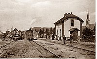
_-_Gare_du_Chemin_de_Fer_d%C3%A9partemental_%C3%A0_voie_%C3%A9troite_de_M%C3%A9zi%C3%A8res_%C3%A0_Wasigny_(Editeur_Winling_%C3%A0_Charleville).jpg)
.jpg)
The Wasigny–Mézières railway was a 43 kilometres (27 miles) long narrow gauge and metre gauge railway line in the north of France, which was put into service in sections from 1897 and operated until 1948.[1]
Route[edit]
The secondary railway line of the Chemins de fer départementaux des Ardennes ran from Wasigny via Signy-l'Abbaye to Mézières in walking distance to the Mohon(fr) und Charleville-Mézières stations.
History[edit]
The Wasigny–Signy section was opened in 1897 as a narrow-gauge railway with the unusual gauge of 800 mm for military reasons, and was only converted to metre gauge when the metre-gauge Signy–Mézières section was built, which opened in 1908. The railway operated until 1948.[1][2][3]
Stations[edit]
-
 Signy-l’Abbaye
 -
 Thin-le-Moutier
 -
 Neuville-lès-This

_-_La_Gare_(01).jpg)
_-_La_Gare.jpg)
References[edit]
- ^ a b Archéologie ferroviaire − Atlas des lignes de chemins de fer disparues. Mézières–Wasigny. Version 2.
- ^ Commune de Thin le Moutier: Du temps où le petit train passait à Thin le Moutier…
- ^ Jean Deal: Le petit train de Mézières a Wasigny.