
Tower of Set
| Tower of Set | |
|---|---|
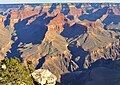
 Southeast aspect, from Tonto Trail | |
| Highest point | |
| Elevation | 6,012 ft (1,832 m)[1] |
| Prominence | 432 ft (132 m)[1] |
| Parent peak | Horus Temple (6,150 ft)[1] |
| Isolation | 1.16 mi (1.87 km)[1] |
| Coordinates | 36°07′16″N 112°10′41″W / 36.1211306°N 112.1780426°W[2] |
| Geography | |
 Tower of Set Location in Arizona  Tower of Set Tower of Set (the United States) | |
| Country | United States |
| State | Arizona |
| County | Coconino |
| Protected area | Grand Canyon National Park |
| Parent range | Kaibab Plateau Colorado Plateau |
| Topo map | USGS Grand Canyon |
| Geology | |
| Type of rock | sandstone, siltstone, mudstone |
| Climbing | |
| First ascent | 1977 |
| Easiest route | class 5.1 climbing[1] |
Tower of Set is a 6,012-foot-elevation (1,832-meter) summit located in the Grand Canyon, in Coconino County of Arizona, US.[2] This butte is situated four miles north of Hopi Point overlook on the canyon's South Rim, two miles southeast of Tower of Ra, and three miles south-southwest of Shiva Temple, where it towers 3,600 feet (1,100 meters) above the Colorado River. Tower of Set was originally named Temple of Sett in 1879 by Thomas Moran, for the Egyptian deity of war, Set, because a niche worn into its wall evoked temples in the valley of the Nile.[2][3] Another source states it was named by George Wharton James, in keeping with Clarence Dutton's tradition of naming geographical features in the Grand Canyon after mythological deities.[4] This mountain's name was officially adopted in 1906 by the U.S. Board on Geographic Names.[2] In 1919, Harriet Williams Russell Strong proposed connecting Hopi Point and Tower of Set across the river via an aerial tramway, an idea that never came to fruition.[4][5] The first ascent was made in November 1977 by Bruce Grubbs and Jim Haggart. According to the Köppen climate classification system, Tower of Set is located in a cold semi-arid climate zone.[6]
Geology[edit]
The top of Tower of Set is composed of the reddish Pennsylvanian-Permian Supai Group.[7] Further down are strata of Mississippian Redwall Limestone, the Cambrian Tonto Group, and finally granite of the Paleoproterozoic Vishnu Basement Rocks at river level. Precipitation runoff from Tower of Set drains due-south to the Colorado River via Trinity Creek (east), and Ninetyfour Mile Creek (west).
See also[edit]
Gallery[edit]
-
 Tower of Set centered. Aerial view from the west.
 -
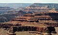
 Tower of Set centered, seen from South Rim
 -
-
 Tower of Set with Tower of Ra beyond
 -
 Tower of Set centered, Shiva Temple behind left
 -
 Tower of Set (centered) from east-southeast, with parent Horus Temple to right and Granite Gorge below
 -
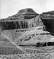 Tower of Set circa 1901
 -


References[edit]
- ^ a b c d e "Tower of Set – 6,012' AZ". Lists of John. Retrieved December 23, 2020.
- ^ a b c d "Tower of Set". Geographic Names Information System. United States Geological Survey, United States Department of the Interior. Retrieved 2020-12-23.
- ^ Gregory McNamee, Grand Canyon Place Names, 1997, Mountaineers Publisher, ISBN 9780898865332, page 110.
- ^ a b Randy Moore and Kara Felicia Witt, The Grand Canyon: An Encyclopedia of Geography, History, and Culture, 2018, ABC-CLIO Publisher, page 211.
- ^ Fodor's Arizona & the Grand Canyon, 2007, ISBN 9781400017065, page 145.
- ^ Peel, M. C.; Finlayson, B. L.; McMahon, T. A. (2007). "Updated world map of the Köppen−Geiger climate classification". Hydrol. Earth Syst. Sci. 11 (5): 1633. Bibcode:2007HESS...11.1633P. doi:10.5194/hess-11-1633-2007. ISSN 1027-5606. S2CID 9654551.
- ^ N.H. Darton, Story of the Grand Canyon of Arizona, 1917, pages 12, 37.
External links[edit]
- Weather forecast: National Weather Service
- Tower of Set photo by Harvey Butchart