
Calverton Historic District
Calverton Historic District | |
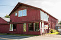
 Calverton Market, at Catlett and Bristersburg Rds. | |
   | |
| Location | Area including parts of Bristersburg and Catlett Rds., Calverton, Virginia |
|---|---|
| Coordinates | 38°37′35″N 77°40′14″W / 38.62639°N 77.67056°W |
| Area | 51 acres (21 ha) |
| Built | 1852 |
| Architectural style | Queen Anne, Late Victorian |
| NRHP reference No. | 10000542[1] |
| VLR No. | 030-5165 |
| Significant dates | |
| Added to NRHP | August 12, 2010 |
| Designated VLR | December 17, 2009[2] |
Calverton Historic District is a national historic district located at Calverton, Fauquier County, Virginia. It encompasses 69 contributing buildings and 2 contributing structures in the rural crossroads village of Calverton. They include three dwellings, a church, a school, and three stores. Notable buildings include a large farmstead, multiple dwellings, several commercial buildings, Wesleyan Methodist Church, the former high school now converted into apartments, and the old abandoned post office building.[3]
It was listed on the National Register of Historic Places in 2010.[1]
Gallery[edit]
-
 Traveler's Inn Restaurant
 -
 Calverton Supply
 -
 Wesleyan UMC
 -
 Flea Market, formerly Spicer's Car Dealership and Motor Co.
 -
 "Maple Hill"
 -
 Old Post Office on Maple Hill Property


References[edit]
- ^ a b "National Register of Historic Places Listings". Weekly List of Actions Taken on Properties: 8/09/10 through 8/13/10. National Park Service. August 20, 2010.
- ^ "Virginia Landmarks Register". Virginia Department of Historic Resources. Archived from the original on September 21, 2013. Retrieved June 5, 2013.
- ^ Maral S. Kalbian and Margaret T. Peters (June 2009). "National Register of Historic Places Inventory/Nomination: Calverton Historic District" (PDF). Virginia Department of Historic Resources. and Accompanying five photos
