
Cinnamon Peak
| Cinnamon Peak | |
|---|---|
 Northeast face | |
| Highest point | |
| Elevation | 2,727 m (8,947 ft)[1] |
| Prominence | 337 m (1,106 ft)[1] |
| Parent peak | Whitehorn Mountain (3399 m)[1] |
| Listing | Mountains of British Columbia |
| Coordinates | 53°04′47″N 119°15′26″W / 53.07972°N 119.25722°W[2] |
| Geography | |
 Cinnamon Peak  Cinnamon Peak | |
| Country | Canada |
| Province | British Columbia |
| District | Cariboo Land District |
| Protected area | Mount Robson Provincial Park |
| Parent range | Park Ranges[1] Canadian Rockies |
| Topo map | NTS 83E3 Mount Robson[2] |
| Climbing | |
| Easiest route | Scrambling |
Cinnamon Peak is a 2,727-metre (8,947-foot) mountain summit located in the northwestern part of Mount Robson Provincial Park, in the Canadian Rockies of British Columbia, Canada. It is situated immediately north of the confluence of the Robson River and the Fraser River, and is visible from the Yellowhead Highway near the park's visitor centre. The peak was labelled "Little Grizzly" on Arthur Oliver Wheeler's 1911 topographic map of Mount Robson.[3] He thought it appeared similar to Mount Grizzly in the Selkirk Mountains, but the name was later changed to Cinnamon, which is the coloration of the peak and the Cinnamon bear, which can be easily mistaken for a grizzly bear.[4] "Little Grizzly" is a colloquial term for the black bear, Ursus americanus. Eastern populations are typically black in color, however western populations can be cinnamon colored.[3] The mountain's toponym was officially adopted in 1951 by the Geographical Names Board of Canada.[2] The nearest higher peak is Whitehorn Mountain, 6.0 km (3.7 mi) to the north.[1]
Climate[edit]
Based on the Köppen climate classification, Cinnamon Peak is located in a subarctic climate zone with cold, snowy winters, and mild summers.[5] Temperatures in winter can drop below −20 °C with wind chill factors below −30 °C. This climate supports an unnamed glacier on the northeast slope of the mountain. The months June through September usually offer the most favorable weather to view or climb the peak. Precipitation runoff from Cinnamon Peak drains into Swiftcurrent Creek and the Robson River, both of which are tributaries of the Fraser River.
See also[edit]
Gallery[edit]
-
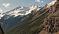 Cinnamon Peak in autumn
 -
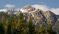
 Cinnamon Peak, glacier centered
 -
 South aspect
 -
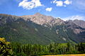 Cinnamon Peak, south aspect
 -
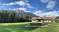 South aspect of Cinnamon Peak (left) and Mount Robson Provincial Park visitor centre.


References[edit]
- ^ a b c d e "Cinnamon Peak". Bivouac.com. Retrieved 2019-10-21.
- ^ a b c "Cinnamon Peak". Geographical Names Data Base. Natural Resources Canada. Retrieved 2019-10-21.
- ^ a b "Cinnamon Peak". BC Geographical Names. Retrieved 2021-04-17.
- ^ "Cinnamon Peak". cdnrockiesdatabases.ca. Retrieved 2021-04-17.
- ^ Peel, M. C.; Finlayson, B. L.; McMahon, T. A. (2007). "Updated world map of the Köppen−Geiger climate classification". Hydrol. Earth Syst. Sci. 11: 1633–1644. ISSN 1027-5606.
External links[edit]
- Mount Robson Provincial Park—BC Parks
- Cinnamon Peak: weather forecast