
Lažai
Lažai | |
|---|---|
Village | |
 | |
 Lažai Location in Lithuania  Lažai Lažai (Lithuania) | |
| Coordinates: 55°28′52″N 23°58′19″E / 55.48111°N 23.97194°E | |
| Country | |
| County | |
| Municipality | Kėdainiai district municipality |
| Eldership | Surviliškis Eldership |
| Population (2011) | |
| • Total | 58 |
| Time zone | UTC+2 (EET) |
| • Summer (DST) | UTC+3 (EEST) |
Lažai ('corvées', formerly Polish: Łoże,[1] Russian: Ложи, Ложе) is a village in Kėdainiai district municipality, in Kaunas County, in central Lithuania. According to the 2011 census, the village had a population of 58 people.[2] It is located 5 km from Surviliškis, by the river Liaudė, nearby Sosiai forest. There is a former school.
Demography[edit]
|
| ||||||||||||||||||||||||||||||
| Source: 1902, 1923, 1959 & 1970, 1979, 1989, 2001, 2011 | |||||||||||||||||||||||||||||||
Images[edit]
-
 A homestead by the road to Užupė
 -
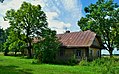 An old Aukštaitian gryčia in Lažai
 -
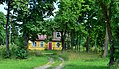 A former school


References[edit]
- ^ "Łoże". Geographical Dictionary of the Kingdom of Poland (in Polish). 15 pt. 2. Warszawa: Kasa im. Józefa Mianowskiego. 1902. p. 277.
- ^ "2011 census". Statistikos Departamentas (Lithuania). Retrieved August 21, 2017.
