
Sommarøy Bridge
Sommarøy Bridge Sommarøybrua | |
|---|---|
 The bridge to Sommarøya in Tromsø municipality | |
| Coordinates | 69°37′25″N 18°02′44″E / 69.62361°N 18.04556°E |
| Carries | |
| Crosses | Sommarøysundet |
| Locale | Tromsø, Troms, Norway |
| Characteristics | |
| Design | Cantilever bridge |
| Total length | 522 metres (1,713 ft) |
| Longest span | 120 metres (390 ft) |
| Location | |
 | |
Sommarøy Bridge (Norwegian: Sommarøybrua) is a cantilever bridge connecting the islands of Kvaløya and Sommarøy in the Hillesøy area of Tromsø Municipality in Troms county, Norway. The prestressed concrete bridge is 522 metres (1,713 ft) long and the longest span on the bridge is 120 metres (390 ft).[1][2]
Sommarøy Bridge has traffic lights to prevent accidents on the narrow bridge, although it has been reported that the traffic lights malfunction in windy weather.[3]
Gallery[edit]
-
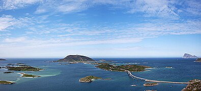 Hillesøya and Sommarøy islands
 -
 Sommarøy Bridge


References[edit]
- ^ Merzagora, Eugenio A. (ed.). "Road Viaducts & Bridges in Norway (> 500 m)". Norske bruer og viadukter. Retrieved 2012-12-09.
- ^ Sommarøy Bridge at Structurae. Retrieved 2012-12-09.
- ^ "Skjørt trafikklys" (in Norwegian). Radio Tromsø. Archived from the original on 2011-07-16. Retrieved 2010-01-09.
External links[edit]
 Media related to Sommarøybrua at Wikimedia Commons
- A picture of Sommarøy Bridge
| Authority control databases: Geographic |
|---|
This article about a location in Troms is a stub. You can help Wikipedia by expanding it. |
This article about a bridge in Norway is a stub. You can help Wikipedia by expanding it. |