
Coppenaxfort
Coppenaxfort is a hamlet in the Nord department in northern France. It is located on the territory of three communes : Brouckerque, Craywick and Bourbourg.
Geography[edit]

Coppenaxfort is located at the junction of Dérivation de la Colme and Canal de Bourbourg canals. The Vliet river flows there too.
History[edit]
Around 1644, the Spanish army build a little fort in the place named Coppenax.
Economy[edit]
The hamlet had a strong industrial activity between 18th and 20th centuries. Famous industries were Duriez distillery (1857-1986), Chevalier flour milling industry (1911-1980), Dambre brewery (1769-1952).
-
 Duriez distillery.
 -
 Motor of the Chevalier flour mill.
 -
 Chevalier flour mill.


Cityscape[edit]
The Craywick side has manors which belong to the Duriez family. Coppenaxfort as a big bridge, which was made in 2009 to replace the old one from 1935.
-
 New Coppenaxfort bridge.
 -
 Château jaune.
 -
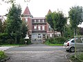 Château rouge.


See also[edit]
50°57′21″N 2°15′47″E / 50.95583°N 2.26306°E
This Nord geographical article is a stub. You can help Wikipedia by expanding it. |