
Bechler Falls
| Bechler Falls | |
|---|---|
 1964 | |
 | |
| Location | Yellowstone National Park, Teton County, Wyoming |
| Coordinates | 44°08′57″N 111°00′36″W / 44.14917°N 111.01000°W[1] |
| Type | Cascade, block |
| Total height | 15 feet (4.6 m) |
| Watercourse | Bechler River |
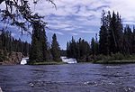
Bechler Falls ht. 15 feet (4.6 m) is a waterfall on the Bechler River in Yellowstone National Park. Bechler Falls is the last waterfall on the Bechler River and is approximately 1 mile (1.6 km) from the confluence with the Fall River. It can be reached via the Bechler River trail approximately 3.5 miles (5.6 km) from the Cave Falls trailhead at the south boundary of the park. The falls were named in 1921 by explorers E. C. Gregg and C.H. Birdseye.[2]
Images of Bechler Falls
-
 1974
1974

See also[edit]
Notes[edit]
- ^ "Bechler River". Geographic Names Information System. United States Geological Survey, United States Department of the Interior.
- ^ Whittlesey, Lee (1996). Yellowstone Place Names. Gardiner, MT: Wonderland Publishing Company. p. 47. ISBN 1-59971-716-6.
Yellowstone National Park - Cascade Corner | ||
|---|---|---|
Rivers, waterfalls, peaks and lakes in the Cascade Corner (Southwest) section of the park | ||
| Rivers |  | |
| Waterfalls and cascades | ||
| Lakes and peaks | ||
| ||
| Authority control databases: Geographic |
|---|
This Wyoming-related article is a stub. You can help Wikipedia by expanding it. |