
Queen Louise Bridge
Queen Louise Bridge | |
|---|---|
 | |
| Coordinates | 55°05′01″N 21°54′20″E / 55.0836°N 21.9056°E |
| Crosses | Neman River |
| Locale | Lithuania–Russia border |
| Characteristics | |
| Total length | 416.3 metres (1,366 ft) |
| Height | 11.4 metres (37 ft) |
| History | |
| Construction end | 1907 |
| Location | |
 | |
The Queen Louise Bridge (German: Königin-Luise-Brücke; Russian: Мост королевы Луизы; Lithuanian: Karalienės Luizos tiltas) is a bridge over the Neman River in Lithuania–Russia border, that connects the Lithuanian town of Panemunė and the Russian city of Sovetsk (historically: Tilsit).[1][2][3][4][5][6][7] It is named after Queen Louise of Mecklenburg-Strelitz.[2]
Gallery[edit]
-
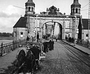 Bridge in 1930
 -
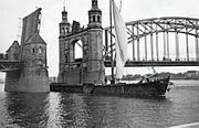 Part of the bridge raised in 1911
 -
 Bridge in 1941
 -
 Lithuanian-side of the bridge in Panemunė with the coat of arms of Lithuania in 1937
 -
 Portrait of Queen Louise of Mecklenburg-Strelitz in the Russian side of the bridge
 -
 View from the Lithuanian side towards the Russian side of the bridge


_in_Panemun%C4%97,_Lithuania,_1937.jpg)


References[edit]
Wikimedia Commons has media related to Queen Louise bridge.
- ^ "Queen Louise Bridge over the Neman River". Visit-Kaliningrad.ru. Retrieved 14 September 2021.
- ^ a b Juška, Albertas; Šilas, Vytautas. "Karalienės Luizės tiltas". Lithuania Minor Encyclopedia (in Lithuanian). Retrieved 14 September 2021.
- ^ "Karalienės Luizės tiltas". PamatykLietuvoje.lt (in Lithuanian). Retrieved 14 September 2021.
- ^ Urbonaitė-Vainienė, Ieva. "Permainingą Lietuvos istoriją atspindinti vieta: įleidžia tik su Rusijos vizomis". DELFI (in Lithuanian). Retrieved 14 September 2021.
- ^ "Karalienės Luizos tiltas – amžių sandūroje". Diena.lt (in Lithuanian). Retrieved 14 September 2021.
- ^ "Panemunė". Universal Lithuanian Encyclopedia (in Lithuanian). Retrieved 14 September 2021.
- ^ Sadauskaitė, Ieva. "Seniausi ir įspūdingiausi tiltai Lietuvoje". WeLoveLithuania.com (in Lithuanian). Retrieved 14 September 2021.
This article about a bridge in Europe is a stub. You can help Wikipedia by expanding it. |