
Taishitun
Taishitun Town
太师屯镇 | |
|---|---|
 Yong'an Street within Taishitun Town, 2012 | |
.png) Location in Miyun District | |
 Taishitun Town  Taishitun Town | |
| Coordinates: 40°32′11″N 117°07′19″E / 40.53639°N 117.12194°E | |
| Country | China |
| Municipality | Beijing |
| District | Miyun |
| Village-level Divisions | 5 communities 34 villages |
| Area | |
| • Total | 219.9 km2 (84.9 sq mi) |
| Elevation | 176 m (577 ft) |
| Population (2020) | |
| • Total | 22,388 |
| • Density | 100/km2 (260/sq mi) |
| Time zone | UTC+8 (China Standard) |
| Postal code | 101505 |
| Area code | 010 |
Taishitun Town (simplified Chinese: 太师屯镇; traditional Chinese: 太師屯鎮; pinyin: Tàishītún Zhèn) is a town located in the Miyun District of Beijing, China.[1] Chao River, Qingshui River and Andamu River converge here before flowing into Miyun Reservoir. The town is situated on the south of Gaoling and Gubeikou Towns, west of Xinchengzi and Wulingshan Towns, northwest of Beizhuang and Dachengzi Towns, as well as northeast of Jugezhuang and Mujiayu Towns. According to the 2020 census, it was home to 22,388 inhabitants.[2]
Prior to the Ming dynasty, this region had been the residence of the Court Astronomer, thus earned the name Taishitun (Chinese: 太史屯; lit. 'Court Astronomer's Village'). Later the name evolved into its current form.[3]
History[edit]
| Year | Status | Belong to |
|---|---|---|
| 1912 - 1928 | Shizha Town | Miyun County, Capital Area |
| 1928 - 1949 | Miyun County, Hebei | |
| 1949 - 1950 | 10th District | |
| 1950 - 1953 | 8th District | |
| 1953 - 1958 | Taishitun Township | |
| 1958 - 1960 | Miyun County, Beijing | |
| 1960 - 1984 | Taishitun People's Commune | |
| 1984 - 1990 | Taishitun Township | |
| 1990 - 2015 | Taishitun Town | |
| 2015–present | Miyun District, Beijing |
Administrative divisions[edit]
As of the time in writing, Taishitun Town is divided into 39 subdivisions, in which 5 are communities and 34 are villages. They are organized into the following list:[4]
| Subdivision Names | Name Transliterations | Type |
|---|---|---|
| 太师屯 | Taishitun | Community |
| 光明 | Guangming | Community |
| 正阳 | Zhengyang | Community |
| 永安 | Yong'an | Community |
| 北山 | Beishan | Community |
| 黄各庄 | Huanggezhuang | Village |
| 许庄子 | Xuzhuangzi | Village |
| 流河峪 | Liuheyu | Village |
| 前八家庄 | Qian Bajiazhuang | Village |
| 后八家庄 | Hou Bajiazhuang | Village |
| 龙潭沟 | Longtangou | Village |
| 上庄子 | Shangzhuangzi | Village |
| 东田各庄 | Dong Tiangezhuang | Village |
| 流河沟 | Liuhegou | Village |
| 葡萄园 | Putaoyuan | Village |
| 太师屯 | Taishitun | Village |
| 太师庄 | Taishizhuang | Village |
| 上金山 | Shangjinshan | Village |
| 大漕村 | Da Caocun | Village |
| 小漕村 | Xiao Caocun | Village |
| 城子 | Chengzi | Village |
| 松树峪 | Songshuyu | Village |
| 东学各庄 | Dong Xuegezhuang | Village |
| 松树掌 | Songshuzhang | Village |
| 桑园 | Sangyuan | Village |
| 黑古沿 | Heiguyan | Village |
| 前南台 | Qian Nantai | Village |
| 后南台 | Hou Nantai | Village |
| 头道岭 | Toudaoling | Village |
| 光明队 | Guangmingdui | Village |
| 二道河 | Erdaohe | Village |
| 车道峪 | Chedaoyu | Village |
| 沙峪 | Shayu | Village |
| 令公 | Linggong | Village |
| 南沟 | Nangou | Village |
| 石岩井 | Shiyanjing | Village |
| 东庄禾 | Dongzhuanghe | Village |
| 马场 | Machang | Village |
| 落洼 | Luowa | Village |
Transportation[edit]
China National Highway 101 and Daqing–Guangzhou Expressway run through the town.
Gallery[edit]
-
 Road to Mt. Wuling near Sangyuan Village, 2012
 -
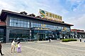 Taishitun Service Area, 2024

.jpg)
See also[edit]
References[edit]
- ^ "Taishitun Town, Miyung, Beijing, China". www.aldpage.com. Retrieved 2018-04-11.
- ^ "北京市密云区第七次全国人口普查公报". www.bjmy.gov.cn. Retrieved 2022-10-31.
- ^ a b 李立国; 李万钧; 吴世民, eds. (2013). 中华人民共和国政区大典, 北京市卷. Beijing: 中国社会出版社. ISBN 978-7-5087-4058-4. OCLC 910451741.
- ^ "2021年统计用区划代码和城乡划分代码". www.stats.gov.cn. Retrieved 2022-10-30.
This Beijing location article is a stub. You can help Wikipedia by expanding it. |