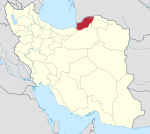
Garu Rural District
Garu Rural District
Persian: دهستان گرو | |
|---|---|
| Coordinates: 37°08′20″N 55°33′14″E / 37.13889°N 55.55389°E[1] | |
| Country | Iran |
| Province | Golestan |
| County | Minudasht |
| District | Kuhsarat |
| Capital | Safiabad |
| Population (2016)[2] | |
| • Total | 11,025 |
| Time zone | UTC+3:30 (IRST) |
Garu Rural District (Persian: دهستان گرو) is in Kuhsarat District of Minudasht County, Golestan province, Iran. Its capital is the village of Safiabad.
After the 2006 census, Kuhsarat Rural District was separated from the Central District in the establishment of Kuhsarat District, which was divided into two rural districts.
At the National Census of 2011, Garu Rural District's population was 11,081 in 2,993 households.[3] At the most recent census of 2016, the population of the rural district was 11,025 in 3,266 households. The most populous of its 11 villages was Dowzeyn (now a city),[4] with 5,737 people.[2]
References[edit]
- ^ OpenStreetMap contributors (14 October 2023). "Garu Rural District (Minudasht County)" (Map). OpenStreetMap. Retrieved 14 October 2023.
- ^ a b "Census of the Islamic Republic of Iran, 1395 (2016)". AMAR (in Persian). The Statistical Center of Iran. p. 27. Archived from the original (Excel) on 29 March 2019. Retrieved 19 December 2022.
- ^ "Census of the Islamic Republic of Iran, 1390 (2011)". Syracuse University (in Persian). The Statistical Center of Iran. p. 27. Archived from the original (Excel) on 17 January 2023. Retrieved 19 December 2022.
- ^ "The mayor and former member of Minudasht city council became the first mayor of Dowzeyn". Golestanema (in Persian). 6 April 2018. Archived from the original on 14 October 2023. Retrieved 14 October 2023.


