
Hungarian Falls
| Hungarian Falls | |
|---|---|
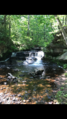
 The middle falls. | |
 | |
| Location | Hubbell, Houghton County, Michigan, United States |
| Coordinates | 47°10′12″N 88°26′30″W / 47.1700000°N 88.4416667°W |
| Elevation | 696 ft |
| Total height | 90 ft |
| Number of drops | 3 |
| Longest drop | 50 ft |
| Average width | 5-10 ft |
| Watercourse | Dover Creek |
Hungarian Falls is a series of waterfalls in the Dover Creek west of Hubbell, in Houghton County, Michigan.[1] The site is near State Highway 26 in the Upper Peninsula of Michigan. There are three drops with the largest being 50 feet. The total height of the falls is 90 feet.[2][3] The base of the waterfall is made up of Jacobsville Sandstone, a type of rock common in that area.[4] Hungarian Falls is also near Michigan's tallest waterfall, Houghton Falls. [5]
Images[edit]
-
 The lower falls.
 -
 The upper falls.
 -
 Sign Marker at Hungarian Falls describing the Jacobsville Sandstone in the area.


References[edit]
- ^ "Report for Hungarian Falls". USGNIS. Retrieved 28 October 2017.
- ^ "Hungarian Falls". Pure Michigan. Michigan Economic Development Corporation. Retrieved 28 October 2017.
- ^ "Hungarian Falls". Great Lakes Waterfalls. Retrieved 28 October 2017.
- ^ "Hungarian Falls". Keweenaw Geoheritage. Retrieved 28 October 2017.
- ^ "Hungarian Falls". Great Lakes Waterfalls. Retrieved 28 October 2017.
This Houghton County, Michigan location article is a stub. You can help Wikipedia by expanding it. |